JISAO data
Outgoing Longwave Radiation (OLR)
There are at least 3 different versions of monthly-mean OLR data:
1) The original version (NOAA NCEP),
2) OLR interpolated in time and space to produce complete fields at the daily day- and night-time level (NOAA CDC), and
3) OLR corrected for changes in equatorial crossing time (SUNY Stony Brook).
The remainder of this page is for the "original version"
data (item 1 above).
Annual mean OLR (W m-2) and Stand. Devia. of montly anomalies (5 W m-2)1979-95
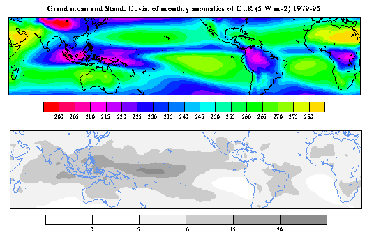
Low annual mean OLR values (<200 Wm-2) associated with deep
atmospheric convection are found over the equatorial land masses,
Amazon basin, and in the western equatorial Pacific. OLR < 200 Wm-2
are also associated with the cold temperatures of the Himalayas. High
annual mean OLR values (>280 Wm-2) are observed over the central and
eastern Sahara and the Arabian Peninsula. The regions of large OLR
variance (>10 Wm-2) are over a broad region of the Indian and Pacific
Oceans with largest values (>20 Wm-2) on and slightly to the south of
the equator in the western Pacific.
Correlation of OLR and Nino3 SST anomalies, all months
1979-Sept.1997
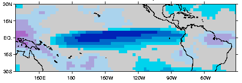
Warm equatorial Pacific SST anomalies are associated with below normal
OLR (enhanced deep atmospheric convection) between 165E and the
Ecuador coast in the equatorial Pacific, and enhanced OLR (diminished
convective rainfall) over Papua New Guinea and eastern equatorial
Brazil. The time series for the average of 65 grid boxes with
correlations < -0.7 is given below.
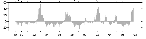 The time series captures the major ENSO episodes in the record. Digital values of this time series are given here.
The OLR fields are prepared by John Janowiak at NOAA NCEP. Questions concerning the method should be directed to John Janowiak.
The data:
The data in netCDF format
There are now two versions of this data. One written in my rendition
of COARDS netCDF convention, and a second where the time variable has
been rewritten by Jon Saenz of the Applied Physics Department of the
University of the Basque Country (Universidad del Pais Vasco) in
Bilbao Spain. The only difference in these data sets is in the time
variable. The version that Jon wrote is
easier to use in the GrADS software. If you have thoughts on this
issue, please send them to me (mitchell@atmos.washington.edu)
and to Jon (jsaenz@wm.lc.ehu.es). Both data sets are for 1974-November 1998 with maps of "NaN"s (missing
value flags) put in for January through May 1974 and March through December of 1978 for which there were no observations. The
December 1998 map is also filled with NaNs. All errors in the netCDF
files are due to Todd Mitchell. The netCDF files are 6.3 Mbytes.
Mitchell version
Saenz version -- more GrADS friendly. Jon also provides on this WWW site the C code used to write the second version of the netCDF file.
The data in binary format (>13 Mbytes). The binary data are updated monthly.
GrADS "ctl" file (metadata) describing the arrangement of the data in the binary file.
online
documentation of the binary file
File of fractional land for each
grid box in netCDF. This file was calculated by myself from the "tbase"
5-minute topography data set, and can be used to construct a landmask.
Reference:
Chelliah, M., and P. A. Arkin, 1992: Large-scale interannual variability of outgoing longwave radiation anomalies over the global tropics. J. Climate, 5, 371-389.
September 2000
Todd Mitchell (mitchell@atmos.washington.edu)
JISAO data