JISAO data
NASA Goddard Institute for Space Studies (GISS) surface temperature anomalies
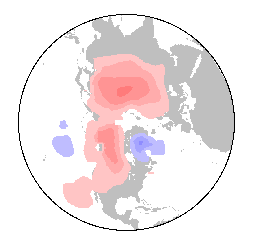
Mean December through April Anomaly, 1979-97
The GISS global surface temperature anomaly data set comes as land data or as land and ocean data, and in two different spatial resolutions: 2.5-degree latitude-longitude (1979-97), and a second, equal-area (and difficult to use) (1880-present) resolution. This data and its documentation are available online.
The 2.5-degree latitude-longitude resolution ocean and land data is available as:
NetCDF file (4.7 Mbytes).
FORTRAN-binary file (<10 Mbytes)
The netCDF file contains data through April of 1997. All errors in the netCDF file are due to Todd Mitchell.
July 1997
Todd P. Mitchell (mitchell@atmos.washington.edu)
JISAO data