JISAO data
"50" km resolution daily precipitation for the Pacific
Northwest, 1949-94
Provided by Martin Widmann and Christopher Bretherton of
the University of Washington
This data have been modified by a model designed to capture
the impact of complex topography on precipitation (Widmann and Bretherton 1999). The data is also
adjusted to so that the 1961-90 climatology is the same as that of the
Parameter-elevation Regressions on Independent Slopes
Model (PRISM) data set for the same period. Please contact Martin Widmann (widmann@gkss.de) with questions
on the analysis method.
Annual total precipitation (mm), 1961-90.
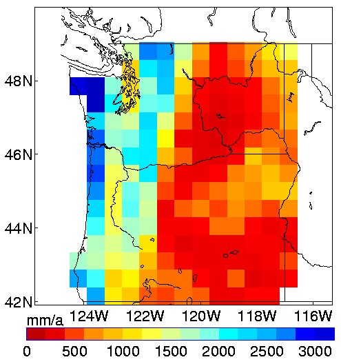
The annual precipitation varies primarily with longitude, with
precipitation in excess of 2.5m at the coast, > 1m in the inland
valleys, >2m in the Cascades, and typically <0.5m to the east of
the Cascades.
November through April total precipitation (cm), 1950-94.
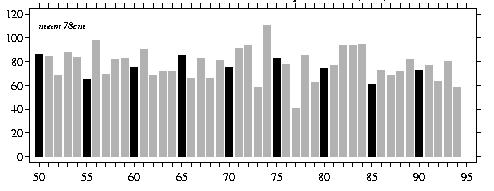
The totals are ascribed to the year of the January. The mean
precipitation is 78 cm. The series exhibits fluctuations from year
to the next in excess of 20 cm. A table of digital
values of this index is linked here.
November through April 1974 total precip. anomalies (cm)
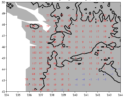
The contour indicates the 1500 m elevation and delineates the Cascade
Mountains, the Columbia Basin, and the eastern Oregon plateau.
A more detailed map of the topography is linked here.
1974 is the wettest winter in the record, with typical anomalies in
excess of 50 cm to the west of the Cascades, 10-20 cm in the Columbia
basin, and near normal rainfall in southeastern Oregon.
November through April 1977 total precip. anomalies (cm)
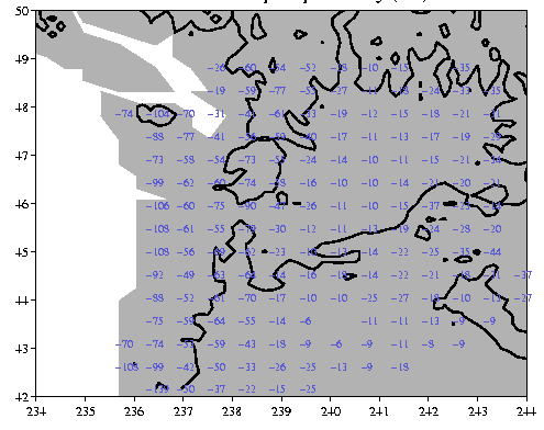
1977 is the driest year in the record with anomalies similar magnitude
to 1974.
The location of stations contributing to the data set.
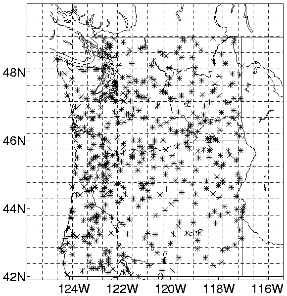
I counted five grid boxes in southeastern Oregon that had no
stations. Most of the grid boxes seem to have two or more stations
within the grid box.
Data:
The data in netCDF
(9.3Mb).
All errors in the netCDF file are due to Todd Mitchell.
Reference:
Widmann, M. and C. S. Bretherton, 2000: Validation of Mesoscale Precipitation in the NCEP Reanalysis Using a
New Gridcell Dataset for the Northwestern United States.
J. Clim., 13, 1936-1950. submmitted manuscript.
Digital values of November through April total precipitation
(mm):
        +0    1    2    3    4    5    6    7    8    9
 1950  862  842  686  876  840  652  980  693  821  828
 1960  755  908  685  717  720  853  659  828  657  808
 1970  748  909  938  582 1104  825  781  404  852  622
 1980  746  770  941  938  942  611  728  687  718  818
 1990  727  770  633  799  586
May 1999
Todd Mitchell (mitchell@atmos.washington.edu)
JISAO data