JISAO data


NOAA NCEP Climate Prediction Center Merged Analysis of Precipitation (CMAP)
Monthly-means for 1979 - September 2004

Introduction | Data


These datasets are prepared by Pingping Xie of NOAA NCEP.


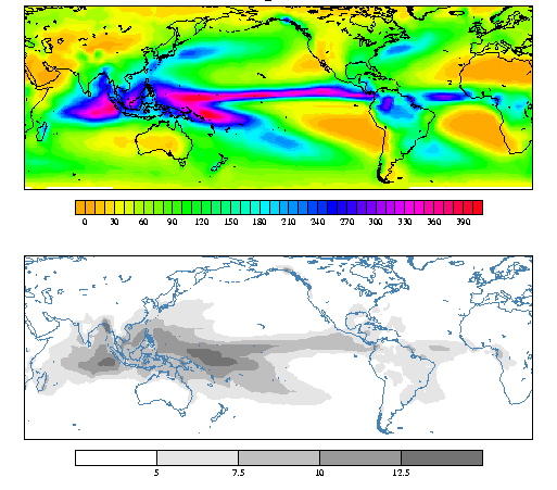
There are two merged precipitation data sets:
1) Rain gauge, 5 satellite estimates( GPI, OPI, SSM/I scattering, SSM/I emission and MSU), and numerical model predictions.
2) Rain gauge, 5 satellite estimates( GPI, OPI, SSM/I scattering, SSM/I emission and MSU)
where OPI stands for OLR-based precipitation index (Janowiak and Xie, 1999).

Important information on how this data set was constructed is provided on the NCEP CPC CMAP WWW page.

A comparison of the CMAP and Global Precipitation Climatology Project (GPCP) merged precipitation datasets is given by:
Yin, X., A. Gruber, and P. Arkinc, 2004: Comparison of the GPCP and CMAP Merged Gauge-Satellite Monthly Precipitation Products for the Period 1979-2001. J. Hydromet., 5, 1207-1222.


Annual total (cm) and standard deviation (cm/mon) of monthly precipitation, 1979-95
Image indicates largest rainfall 
amounts over the oceans, with the deep convective regions of the
 western 
 Pacific emphasized over the eastern Pacific (c.f. MSU).  Wetter places
 are more variable.
The largest annual totals (standard deviation) are > 4m (>12.5 cm/mon). This analysis is calculated for estimate 2 above: derived from rain gauge, MSU, GPI, and 2 SSM/I products.


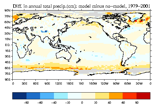
The standard version of this dataset is constructed from rain gauge and satellite measurements. The "enhanced" version also includes model precipitation. The following analysis, the difference of the mean with and without model precipitation, shows that the largest influence of the model precipitation is in the highest latitudes (near and over ice).
global domain
PostScript | JPEG

JFMAM-average 1983 and 1998 precipitation (>8 cm/mon)
Image for 
South America. Image for 
South America.
Both years are characterized by precipitation in excess of 24 cm/month in the Pacific and Atlantic Oceanic ITCZs, along the Ecuador and northern Peru coast, where the Amazon flows into the Atlantic, portions of the Amazon basin, and Paraguay-southern Brazil-northern Uruguay.

The data:

  • In netCDF format:
    At JISAO, these files may be found at /home/disk/muggy/data/merged_precip/cmap
    rain rate (mm/day) (with model input) (6.5 Mbytes).
    rain amount (cm/mon) (with model input) (6.5 Mbytes).
    rain rate (mm/day) (no model input) (6.5 Mbytes).
    rain amount (cm/mon) (no model input) (6.5 Mbytes).
  • The data and documentation are available in ASCII from the NCEP CPC CMAP WWW page.

    References:
    Xie, P., and P. A. Arkin, 1997: Global Precipitation: A 17-year monthly analysis based on gauge observations, satellite estimates, and numerical model outputs. Bull. Amer. Meteor. Soc., 78, 2539-2558.
    Janowiak, J. E. and P. Xie, 1999: CAMS-OPI: A global satellite-rain gauge merged product for real-time precipitation monitoring applications, J. Climate, 12, 3335-3342.

    Questions concerning the method used to merge the preciptation estimates should be directed to Pingping Xie ( Pingping.Xie@noaa.gov ).


    April 2005
    Todd Mitchell ( mitchell@atmos.washington.edu )
    JISAO data