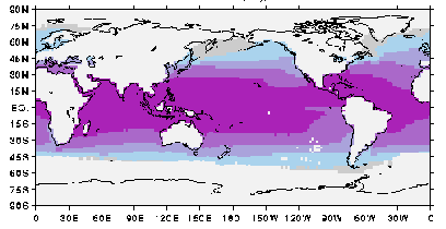
JISAO data

ICOADS (marine data) climatologies

This WWW page provides several climatologies derived from the International Comprehensive Ocean-Atmosphere Data Set (ICOADS).

I usually use the period 1950-79 for climatologies as there is relatively good sampling and relatively little decadal variability during this period. A 1900-79 SST climatology is also provided. Up until recently ICOADS was only available in 2-degree latitude-longitude resolution. One-degree latitude-longitude data is now available, and an SST climatology based on this data for 1960-79 is also provided. The 1-degree data begins in 1960 at this time. For each climatology, the contribution of each month and year to the climatology is weighted by the number of observations in that month and year. All observations are used.

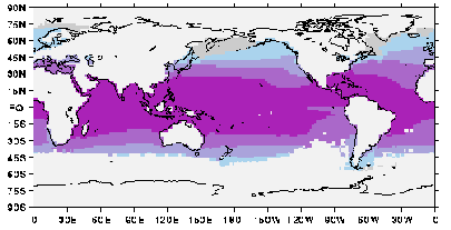
The annual mean for the two SST climatologies are shown below to indicate the coverage of each climatology. Shading indicates regions with climatological values for all calendar months. The high-latitude oceans may have climatological values only for their summers.

1900-79
Global domain plotted.
1950-79

Image described 
below.
Shading interval 6C. Both climatologies have values between 75N and 40S. The 1900-79 climatology has values for the southeast Pacific and southwest Atlantic.

Data in netCDF format:
At JISAO: /home/disk/margaret2/jisao/data_sets/coads_climatologies/
1950-79 climatologies (~0.4 Mb)

  • sea surface temperature (SST)
  • sea-level pressure (SLP)
  • cloudiness (percent of the sky covered with clouds)
  • zonal component of surface wind
  • meridional component of surface wind
    1900-79 climatology
  • sea surface temperature (SST)
    1960-79 1-degree resolution climatology
    In the following, the files of "climatology + annual mean" comprise 13 maps (January, February, ..., December, and annual mean), and the "annual mean" files are just the annual mean. (Software on the WWW for viewing maps tend not to be sophisticated enough to handle the "climatology + annual mean" configuration.)
  • sea surface temperature (SST) climatology + annual mean
  • sea surface temperature (SST) annual mean
    Smoothed versions of the fields are also provided. The smoothing employed are successive 5- and 3-point running means along latitude-circles. This filter removes some of the noisiness, but unfortunately also fills in coastal land points.
  • smoothed sea surface temperature (SST) climatology + annual mean
  • smoothed sea surface temperature (SST) annual mean


    November 2002
    Todd Mitchell ( mitchell@atmos.washington.edu )
    JISAO data