JISAO data
Elevation data in netCDF
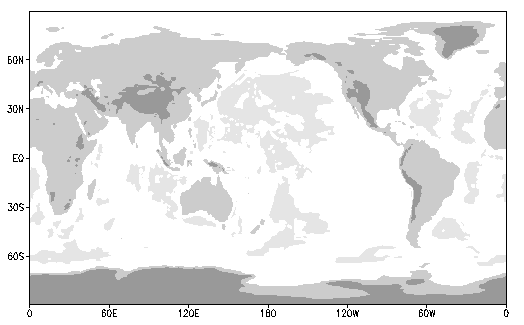
1-degree latitude-longitude resolution elevations, light shading for
elevations < -5000m, and increasingly darker shades for elevations > 0
and 1500m. This choice of shading captures the deeper parts
of the world oceans, the Himalayas, Rockies, and the Andies, and shows
that much of Antarctica is a high plateau. The elevation
data set used for this figure is linked here (in netCDF).
I downloaded a dataset 5-minute resolution from the National Center
for Atmospheric Research called "TerrainBase" (TBASE). That WWW page
no longer exists or the dataset has been renamed.
There is a 2-minute elevation data set at the National
Geophysical Data Center (NGDC) called ETOPO2.
At JISAO, all of these files reside at /home/disk/margaret2/data_sets/elevation/
5-minute latitude-longitude
resolution elevation for just the Americas TBASE
0.25-degree latitude-longitude resolution
elevation (TBASE)
0.5-degree latitude-longitude resolution
elevation (TBASE)
0.75-degree latitude-longitude resolution
elevation (ETOPO5) shares the same gridpoints
as the ERA interim reanalysis grid
1-degree latitude-longitude resolution
elevation (Rand Corporation / Scripps Institution of Oceanography)
1.5-degree latitude-longitude resolution
elevation (ETOPO5) shares the same gridpoints
as the ERA interim reanalysis grid
2-degree latitude-longitude resolution
elevation (TBASE)
fractional land (0-1) at
0.25-degree latitude-longitude resolution.
fractional land (0-1) at
0.5-degree latitude-longitude resolution.
fractional land (0-1) at
1-degree latitude-longitude resolution.
fractional land (0-1) at
2-degree latitude-longitude resolution.
fractional land (0-1) at
2.5-degree latitude-longitude resolution.
fractional land (0-1) at
5-degree latitude-longitude resolution.
How to shade continents in GrADS.
GrADS is free software that employs a command-line interface (you type commands in). The following describes
how to draw the figure at the top of this WWW page.
grads  * To start the session

* Define some gray shades
set rgb 16 153 153 153
set rgb 18 205 205 205
set rgb 19 230 230 230

sdfopen elev.1-deg.nc

set background 0
set mpdraw off
set grid off
set grads off

set dfile 1
set gxout shaded
set clevs -1500 0 1500
set ccols 19 0 18 16
d data
December 2014
Todd Mitchell (mitchell@atmos.washington.edu)
JISAO data