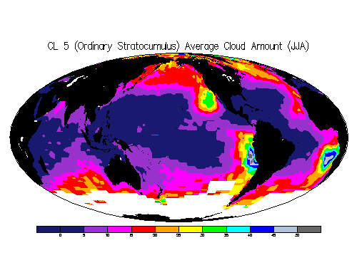
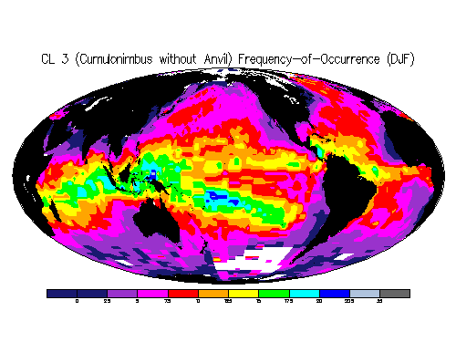
This is a dataset of daytime-only seasonal climatologies of individual low cloud types over the ocean constructed by Joel Norris for the time period 1954-1992 using synoptic surface ship observations. Available parameters are frequency of occurence, amount when present, and average cloud amount. The ship observations were obtained from a preliminary release of the Extended Edited Cloud Report Archive (EECRA) [please contact Carole Hahn for information regarding the EECRA (expected to be released in 1998)].
Two climatologies are presented below. Color intervals every 5% (top) and 2.5% (bottom).
The data are available in three formats:
and may be freely distributed under the following conditions:
All formats provide data at 2.5 x 2.5 resolution (72 x 144 gridpoints). The first value in the binary and ASCII files is at 88.75 N, 1.25 E, the second at 88.75 N, 3.75 E, etc., to the last value at -88.75 N, 358.75 E. Missing data is indicated by -999. Units are percent. Various abbreviations are defined here ,and informal descriptions of the synoptic low cloud types are provided here.
A more detailed description of how the low cloud type climatologies were constructed can be found in (Norris 1998) , which displayed maps of low cloud type frequency-of-occurrence during JJA and DJF. Low cloud type observations were averaged in irregularly-sized grid boxes to increase resolution in well-sampled regions of the ocean and to decrease statistical noise in poorly-sampled regions of the ocean (irregular grid box coordinates in ASCII format available here). These grid box values were transferred to a regular 2.5 degree grid by assigning the irregular grid box value to all 2.5 degree grid boxes within it. The same irregular size grid was used for all seasons but grid box averages with less than 100 observations contributing were discarded (number of observations for each irregular grid box in ASCII format available here). Norris (1998) displays irregularly-sized grid box maps for JJA and DJF.
Informal low cloud type descriptions:
Note that SOP and FOG are not identified as low cloud types (CL) by the WMO synoptic code but are classified as "low cloud types" in this dataset in order to include all possible sky conditions
Reference:
Norris, J. R., 1998: Low cloud type over the ocean from surface observations. Part II: geographical and seasonal variations. Journal of Climate,11,383-403.