PostScript | JPEG | digital values (netCDF)
For the study of high-latitude Northern Hemisphere climate, a 1-degree latitude-longitude resolution data set is provided that is the merge of data from three sources. Land data is from the University of Delaware (UD); marine data (primarily away from the Arctic) is from the Comprehensive Ocean-Atmosphere Data Set (COADS); and marine data primarily at the Arctic is from the International Arctic Buoy Programme and Polar Exchange at the Sea Surface (IABP/POLES). The merging of these data sets is documented below.
The UD data (version 1.02) spans 1950-99, and its native resolution is
0.5-degrees latitude-longitude. I have averaged this data into a
1-degree latitude-longitude resolution version.
I am using the 1-degree latitude-longitude version of COADS
("enhanced" quality control), and this
spans 1960-97. There are spurious observations in (41-46N,175-170W;
41-46N,165-160W), and I have replaced these with interpolated
values.
The IABP/POLES data provides values for both land and sea for
1979-98. The grid is reminiscent of the old National Meteorological
Center octagonal grid. I interpolated this data set onto a 1-degree
latitude-longitude resolution grid, using the Cressman scheme with an
e-folding scale of 1-degree latitude.
UD data is available for each month, COADS is put in for the marine
observations, and IABP/POLES values are used to fill the remaining
marine grid boxes. The contributions of COADS and IABP/POLES during
the common years 1979-97 are shown below.
Details:
The merging process employed is simple, but yields a useful data set.
There is certainly room for more sophisticated treatment.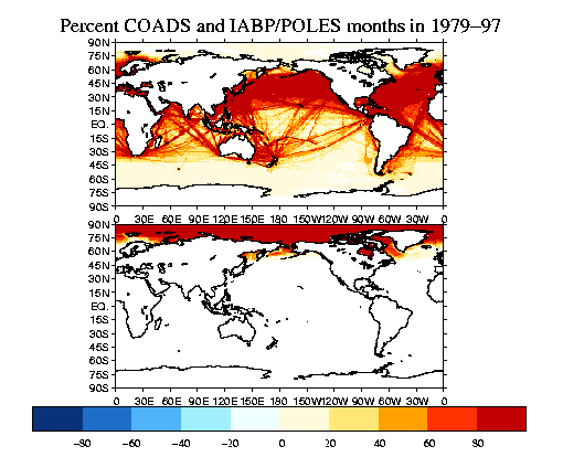
PostScript | JPEG
Data in netCDF format:
At JISAO: /home/disk/muggy/data/gridded_land_and_ocean_temp/merged_arctic/
December 2002
Todd Mitchell ( mitchell@atmos.washington.edu
)
JISAO data