| Latitude 37° 7´N |
Longitude 84° 4´W |
Elevation 384 meters |
 COOP Mid-Atlantic |
 Kentucky |
Help Main |
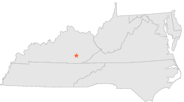
| 2 mi | WNW : | LONDON STATE POLICE, KY |
| 2 mi | SSW : | LONDON LONDON-CARBIN AP, KY |
| 11 mi | SSW : | CORBIN CAA AIRPORT, KY |
| 12 mi | S : | CORBIN, KY |
| 14 mi | E : | MANCHESTER 4 W, KY |
| 17 mi | E : | MANCHESTER, KY |
| 19 mi | SSE : | BARBOURVILLE, KY |
| 21 mi | NNE : | GRAY HAWK, KY |
| 22 mi | NW : | MOUNT VERNON, KY |
| 22 mi | N : | MC KEE, KY |