| Latitude 38° 7´N |
Longitude 82° 37´W |
Elevation 177 meters |
 COOP Mid-Atlantic |
 Kentucky |
Help Main |
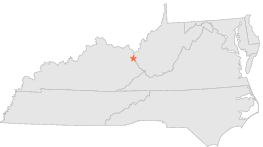
| 1 mi | E : | LOUISA 2 S, KY |
| 5 mi | WNW : | LOUISA 5 W, KY |
| 9 mi | WNW : | FALLSBURG 5 NW, KY |
| 11 mi | W : | WEBBVILLE 6 SE, KY |
| 12 mi | NE : | WAYNE, WV |
| 12 mi | NE : | WAYNE 2, WV |
| 13 mi | E : | EAST LYNN LAKE, WV |
| 13 mi | WSW : | BLAINE, KY |
| 16 mi | SE : | DUNLOW 1 SW, WV |
| 17 mi | ESE : | CABWAYLINGO STATE FOREST, WV |