| Latitude 39° 43´N |
Longitude 76° 39´W |
Elevation 256 meters |
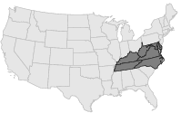
 COOP Mid-Atlantic |
 Maryland |
Help Main |
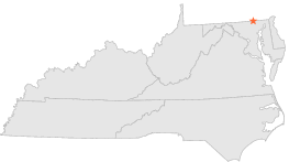
| 4 mi | SW : | BENTLEY SPRINGS 1 WNW, MD |
| 6 mi | SSW : | PARKTON 2 SW, MD |
| 6 mi | SSW : | PRETTYBOY DAM, MD |
| 7 mi | S : | WHITE HALL, MD |
| 8 mi | W : | MILLERS 4 NE, MD |
| 15 mi | S : | COCKEYSVILLE 2 NE, MD |
| 19 mi | SE : | FALLSTON, MD |
| 20 mi | SSE : | LOCH RAVEN DAM, MD |
| 20 mi | SW : | WESTMINSTER POL BRKS, MD |
| 21 mi | SE : | BENSON POLICE BARRACKS, MD |