| Latitude 38° 8´N |
Longitude 78° 27´W |
Elevation 190 meters |
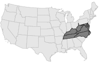
 COOP Mid-Atlantic |
 Virginia |
Help Main |
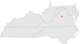
| 7 mi | WSW : | FREE UNION, VA |
| 8 mi | SSW : | CHARLOTTESVILLE 2 W, VA |
| 8 mi | SSW : | CHARLOTTESVILLE 1 SW, VA |
| 8 mi | S : | MONTICELLO, VA |
| 13 mi | NE : | SOMERSET, VA |
| 14 mi | WSW : | CROZET 2 N, VA |
| 15 mi | ESE : | GORDONSVILLE 3 S, VA |
| 17 mi | ESE : | GORDONSVILLE FAA AP, VA |
| 19 mi | ENE : | PIEDMONT RESEARCH STN, VA |
| 20 mi | NE : | MADISON 4 ESE, VA |