| Latitude 42° 21´N |
Longitude 89° 3´W |
Elevation 226 meters |
 COOP Midwest |
 Illinois |
Help Main |
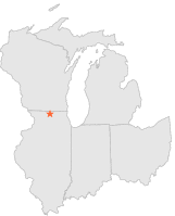
| 5 mi | SE : | ROCKFORD 6 ENE, IL |
| 5 mi | SSW : | ROCKFORD, IL |
| 10 mi | N : | BELOIT, WI |
| 12 mi | SE : | BELVIDERE, IL |
| 12 mi | NW : | SHIRLAND, IL |
| 18 mi | NE : | CLINTON, WI |
| 18 mi | N : | AFTON, WI |
| 21 mi | S : | LINDENWOOD, IL |
| 22 mi | ENE : | HARVARD, IL |
| 22 mi | N : | JANESVILLE, WI |