| Latitude 40° 14´N |
Longitude 85° 23´W |
Elevation 298 meters |
 COOP Midwest |
 Indiana |
Help Main |
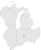
| 2 mi | WSW : | MUNCIE BALL STATE UNIV, IN |
| 4 mi | SSE : | MUNCIE, IN |
| 7 mi | SSE : | MUNCIE 4 SE, IN |
| 12 mi | E : | FARMLAND 5 NNW, IN |
| 14 mi | S : | SPRINGPORT, IN |
| 16 mi | NNE : | HARTFORD CITY 4 ESE, IN |
| 16 mi | WNW : | ALEXANDRIA 2 N, IN |
| 16 mi | SW : | ANDERSON MOUNDS STATE PARK, IN |
| 16 mi | SW : | MIDDLETOWN 2 W, IN |
| 17 mi | NNW : | UPLAND 1 S, IN |