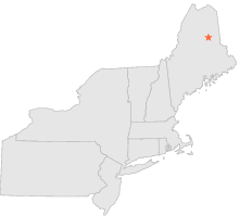
176585 - PATTEN, Maine

Latitude
46° 1´N
Longitude
68° 27´W
Elevation
214 meters

COOP Northeast

Maine
Help

Main
10 nearest COOP Northeast stations
1 miS :PATTEN, ME
2 miS :PATTEN 1 S, ME
2 miW :PATTEN 2, ME
5 miSW :PATTEN 4 WSW, ME
24 miESE :HAYNESVILLE, ME
27 miNW :MILLINOCKET DAM, ME
28 miSSW :MILLINOCKET MUNICIPAL ARPT, ME
28 miSSW :MILLINOCKET, ME
31 miENE :HOULTON, ME
32 miENE :HOULTON 5 N, ME

Weather variables    Help
Click a weather variable name to jump down to those statistics.
Total
observations
%
NDJFM
observations
%
TMAX
232
1.3%
0
0.0%
TMIN
231
1.3%
0
0.0%
PRCP
258
1.4%
29
0.4%
SNOW
215
1.2%
0
0.0%


TMAX     top of page

Data not shown:
Less than 5% of days have TMAX observations during NDJFM over 1948-1997

No TMAX extreme events during NDJFM over 1948-1997


TMIN     top of page

Data not shown:
Less than 5% of days have TMIN observations during NDJFM over 1948-1997

No TMIN extreme events during NDJFM over 1948-1997


PRCP (total liquid water equivalent)     top of page

Data not shown:
Less than 5% of days have PRCP observations during NDJFM over 1948-1997


SNOW     top of page

Data not shown:
Less than 5% of days have SNOW observations during NDJFM over 1948-1997

No days with measureable SNOW during NDJFM over 1948-1997