| Latitude 45° 54´N |
Longitude 69° 58´W |
Elevation 335 meters |
 COOP Northeast |
 Maine |
Help Main |

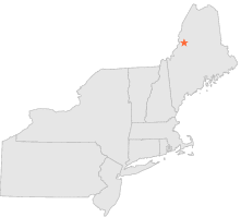
| 3 mi | NW : | COMSTOCK, ME |
| 18 mi | SSE : | BRASSUA DAM, ME |
| 23 mi | SW : | JACKMAN, ME |
| 25 mi | SSE : | MOOSEHEAD, ME |
| 30 mi | S : | HARRIS STATION, ME |
| 35 mi | SSE : | GREENVILLE, ME |
| 36 mi | S : | WEST FORKS, ME |
| 38 mi | E : | RIPOGENUS DAM, ME |
| 38 mi | S : | THE FORKS, ME |
| 44 mi | ENE : | TELOS DAM, ME |