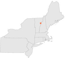
430724 - BOLTONVILLE, Vermont

Latitude
44° 11´N
Longitude
72° 6´W
Elevation
201 meters

COOP Northeast

Vermont
Help

Main
10 nearest COOP Northeast stations
2 miNE :EAST RYEGATE, VT
5 miWNW :GROTON, VT
6 miNNE :MC INDOE FALLS, VT
6 miESE :BATH 2 SSW, NH
9 miS :SOUTH NEWBURY, VT
9 miN :WEST BARNET, VT
10 miNNE :MONROE 5 NNE, NH
10 miWSW :WEST TOPSHAM, VT
11 miE :LANDAFF, NH
12 miESE :BENTON, NH

Weather variables    Help
Click a weather variable name to jump down to those statistics.
Total
observations
%
NDJFM
observations
%
TMAX
0
0.0%
0
0.0%
TMIN
0
0.0%
0
0.0%
PRCP
363
2.0%
149
2.0%
SNOW
359
2.0%
145
1.9%


TMAX     top of page

Data not shown:
Less than 5% of days have TMAX observations during NDJFM over 1948-1997

No TMAX extreme events during NDJFM over 1948-1997


TMIN     top of page

Data not shown:
Less than 5% of days have TMIN observations during NDJFM over 1948-1997

No TMIN extreme events during NDJFM over 1948-1997


PRCP (total liquid water equivalent)     top of page

Data not shown:
Less than 5% of days have PRCP observations during NDJFM over 1948-1997


SNOW     top of page

Data not shown:
Less than 5% of days have SNOW observations during NDJFM over 1948-1997