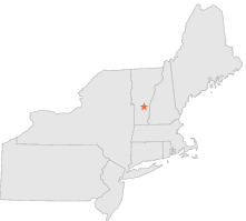
438512 - TYSON, Vermont
Latitude
43° 28´N
Longitude
72° 42´W
Elevation
336 meters
COOP Northeast
Vermont
Help
Main
10 nearest COOP Northeast stations
5 mi
N :
PLYMOUTH, VT
5 mi
S :
LUDLOW, VT
5 mi
NNW :
PLYMOUTH UNION, VT
8 mi
ENE :
READING HILL, VT
8 mi
SE :
CAVENDISH, VT
8 mi
E :
WEST WINDSOR, VT
12 mi
E :
BROWNSVILLE, VT
13 mi
SSW :
WESTON, VT
13 mi
SE :
NORTH SPRINGFIELD, VT
13 mi
SSW :
WESTON 1 S, VT
Weather variables
Help
Click a weather variable name to jump down to those statistics.
Total
observations
%
NDJFM
observations
%
TMAX
0
0.0%
0
0.0%
TMIN
0
0.0%
0
0.0%
PRCP
1003
5.5%
359
4.7%
SNOW
26
0.1%
26
0.3%
TMAX
top of page
Data not shown:
Less than 5% of days have TMAX observations during NDJFM over 1948-1997
No
TMAX extreme events
during NDJFM over 1948-1997
TMIN
top of page
Data not shown:
Less than 5% of days have TMIN observations during NDJFM over 1948-1997
No
TMIN extreme events
during NDJFM over 1948-1997
PRCP
(total liquid water equivalent)
top of page
Data not shown:
Less than 5% of days have PRCP observations during NDJFM over 1948-1997
SNOW
top of page
Data not shown:
Less than 5% of days have SNOW observations during NDJFM over 1948-1997
No days with
measureable SNOW
during NDJFM over 1948-1997