
For a postscript version of this plan with a set of black and white figures, click here.
Over its ten-year lifetime, the Tropical Ocean-Global Atmosphere
(TOGA) program (1985-1995) made major strides toward understanding of
the El Niño/Southern Oscillation (ENSO) phenomenon, which
impacts surface air temperature and rainfall over many regions of the
globe. In particular, TOGA demonstrated the feasibility of
operational seasonal-to-interannual climate prediction of equatorial
Pacific sea surface temperature anomalies based on numerical models
that simulate, in a rudimentary manner, the physics of the coupled
tropical ocean-atmosphere system, and it clarified the nature of the
remote, planetary-scale atmospheric response to these anomalies. The
U.S. Global Ocean-Atmosphere-Land System (GOALS) program is predicated
on the belief that the skill of operational climate prediction can be
further increased by continued research on ENSO and by efforts to
understand other elements of the climate system that contribute to the
observed seasonal-to-interannual variability. The Pan American
Climate Studies (PACS) program is a component of the U.S. GOALS
program in the 1995-2005 time frame which provides a phenomenological
context for some of the GOALS research.
The overall goal of PACS is to extend the scope and improve the
skill of operational seasonal-to-interannual climate prediction over
the Americas. Particular emphasis is placed on warm season rainfall,
for which a predictive capability does not yet exist. In the context
of PACS, climate prediction is also concerned, not only with seasonal
mean rainfall and temperature, but also with the frequency of
occurrence of significant weather events such as hurricanes or floods
over the course of a season or seasons.
The scientific objectives of PACS are to promote a better
understanding and more realistic simulation of (1) the boundary forcing
of seasonal to interannual climate variations over the Americas, (2)
the evolution of tropical SST anomalies, (3) the seasonally varying
mean climate over the Americas and adjacent ocean regions, (4) the
time-dependent structure of the ITCZ/cold tongue complex, and (5) the
relevant land surface processes.
To state these objectives more explicitly:
PACS scientific objectives (i) and (ii) directly address the
scientific objectives of the GOALS program: (i) relates to atmospheric
prediction and (ii) to prediction of tropical SST; in this sense they
may be viewed as primary. Objectives (iii), (iv), and (v) play a
supportive role by advancing understanding of the mechanisms that give
rise to and limit the predictability of the coupled global
ocean-atmosphere-land system: (iii) and (iv) relate to the prediction
of ENSO and other phenomena that give rise to tropical SST anomalies,
and (v) relates to the prediction of continental rainfall.
PACS encompasses a broad range of activities, including empirical
studies, data set development, modeling, climate monitoring, and more
intensive, limited term field experiments. In order to avoid being
spread too thin, the field studies will focus on different regions of
the Pan-American climate system in sequence. During the first five
years they will focus on atmosphere-ocean interaction in the tropical
eastern Pacific, in association with the ENSO cycle and the
climatological-mean annual march. During the second half of PACS the
emphasis will shift to the tropical Atlantic Ocean where the SST
anomalies are more subtle and more diverse in terms of horizontal
structure than in the Pacific, but no less important in terms of their
influence upon precipitation in the adjacent continental regions.
The phenomenological basis for PACS is outlined in the Scientific
Prospectus. This Implementation Plan spells out in more detail,
the research that will be carried out in pursuit of the scientific
objectives of the program. Section 2 discusses the practical and
scientific motivation for the program and sections 3-5 describe the
empirical studies, dataset development, and modeling that will be
conducted under its auspices. Section 6 describes the field studies
envisioned for PACS, starting with projects already funded and going
on to describe activities likely to be proposed for the 1997-2000 time
frame. Section 7 discusses linkages with other programs: specifically
the Global Energy and Water Experiment (GEWEX) and its regional
programs, NASA's Tropical Rainfall Measurement Mission (TRMM), and the
Atlantic Circulation and Climate Experiment (ACCE). Program
management is discussed in section 8. Within the U.S., interagency
support is being sought for PACS, with coordination by the GOALS
Project Office. The Inter American Institutes (IAIs) serve as a
vehicle for coordinating international cooperation.
Figure 1 shows a selection of time series illustrating the large
year-to-year variability of seasonal-mean rainfall. Features visible
in these plots include the anomalous summer of 1993, marked by
disastrous floods in the central U.S. and drought in the southeast,
and the summers of 1988 and 1991 in which the farmers in the central
U.S. suffered major drought-related crop losses. Longer time scale
features such as the legendary "dust bowl" epoch in the central
U.S. in the 1930's are also evident. In semiarid regions, such as
parts of Arizona and northeast Brazil, the interannual variability
tends to be even larger in relation to the seasonal mean rainfall,
rendering agriculture a high-risk venture.
Following upon the success of TOGA, government agencies in Peru (Lagos and Buizer 1992) and Brazil have been
incorporating El Niño predictions into their agricultural
planning for several years now. A beneficial impact of the forecasts
is suggested by Table 1, which shows grain production for a number of
recent years in the state of Ceara in northeast Brazil and
corresponding rainfall totals over the state, both expressed as
percentages of normal. The moderately severe drought conditions that
prevailed in 1987 have been blamed for the drastically reduced grain
production that year. Similar drought conditions in 1992, after the
advent of climate prediction, reduced agricultural production only
slightly, and even the much more severe drought that prevailed the
following year had a less adverse impact on grain production than the
1987 drought.
Table 1. Grain production and growing season rainfall in the
state of Ceara in northeast Brazil, for selected years, both expressed
as percentages of the long-term mean.
On the basis of empirical studies, a number of significant
relationships between anomalies in tropical SST anomalies and
concurrent or subsequent rainfall anomalies over the Americas have
been identified. A few of the concurrent relationships are illustrated in
Fig. 2. Rainfall on the coastal plain of Ecuador and northern Peru is
positively correlated with SST in the equatorial Pacific. The same
distinctive "El Niño signature" is apparent, with varying
degrees of strength, in several of the other correlation
maps. Tropical Atlantic SST signatures are also apparent in several of
the patterns: particularly the one for February-May rainfall in
northeast Brazil.
The existence of significant correlations does not, in itself,
constitute proof that SST anomalies in some particular ocean region
influence rainfall within a prescribed continental region. In the
coupled atmosphere-ocean system, inference of causality on the basis
of empirical evidence alone is fraught with ambiguity. The role of
such empirical evidence suggests the kinds of modeling
experiments that need to be conducted in order to establish causality.
The influence of ENSO upon rainfall in Ecuador, as well as in more
remote regions such as the southeastern United States has, in fact,
been verified on the basis of numerous experiments with atmospheric
general circulation models (AGCMs), and the dynamical mechanisms that
give rise to the remote response are reasonably well understood. In a
similar manner, it is well established that SST anomalies in the
tropical Atlantic are capable of influencing northeast Brazil
rainfall.
Theoretical considerations suggest that the extratropical response
to tropical SST anomalies should be strongest during the cold season,
in agreement with empirical evidence. Hence, most of the AGCM
investigations that have been conducted thus far have been based on
wintertime conditions. In the absence of confirmatory AGCM
simulations, the correlation pattern for summer rainfall over the
U.S. Great Plains in Fig. 2 is difficult to interpret. For example,
it is possible that the North Pacific features in the SST correlation
pattern are induced by the same atmospheric circulation anomalies that
are responsible for the rainfall anomalies. Whether the hint of an
ENSO signature in the pattern is indicative of a causal relationship
remains to be seen.
Results of several published AGCM studies suggest that equatorial
SST anomalies associated with ENSO might, in fact, be capable of
influencing warm season rainfall over the Americas. Furthermore,
there is evidence, based on statistics of hurricane frequency that the
ENSO cycle exerts a far reaching influence on summertime climate in
the PACS domain. Figure 3 shows the position of the Atlantic storms on
the last day that they exhibited hurricane force winds for two sets of
years, classified on the basis of an index of equatorial Pacific SST.
More than twice as many storms enter the Gulf of Mexico and make
landfall along its coastline during the cold years as during the warm
years. Figure 4 shows analogous warm versus cold year composites, but
for hurricane and tropical storm days. Warm years of the ENSO cycle
are characterized by more Pacific storm days in general, and more of
the storms reach northwestern Mexico and Hawaii before they dissipate.
Hence the ENSO cycle apparently affects the partitioning of the storms
between the Caribbean/Gulf of Mexico and the eastern Pacific.
Warm season rainfall over the Americas is influenced, not only by
tropical SST anomalies, but also by land surface processes.
Evapotranspiration from vegetation is an important moisture source for
precipitation systems, and it exerts a strong influence on daytime
surface air temperature and static stability, which feed back upon the
dynamical variables. Under certain circumstances, the two kinds of
boundary forcing could be coupled: e.g., with springtime SST anomalies
modulating the moisture available to support the growth of vegetation,
and the vegetation, in turn, feeding back upon the summer rainfall and
daytime temperatures. In a similar manner, precipitation anomalies
during the previous month or season could precondition the warm season
climate through their influence on vegetation and soil moisture, as
evidenced by the observed tendency for anomalously hot months to
follow anomalously dry months during the warm season. Lead-lag
correlation statistics analogous to those presented in Fig. 2 have
been used with a limited degree of success as a basis for prediction
of temperature and rainfall over the United States, the numbers of
Atlantic hurricanes, and indices of equatorial Pacific SST anomalies.
However, in view of the high degree of nonlinearity of the climate
system and the limited duration of the observational record, it will
be difficult to achieve major advances in state-of-the-art of
climate prediction without a better understanding of the physical
processes that determine the mean state of the climate system and
govern its time-dependent behavior. The gaps in current knowedge of
the physics are reflected in the rather large and pervasive systematic
biases in climate simulations, as described in Section 5.4. PACS
field studies will be designed to supply the basic information needed
to diagnose and correct these deficiencies in the model physics.
PACS will promote an improved understanding of the processes that
control the distribution of rainfall over the Americas and apply that
knowledge to improve the models used for seasonal-to-interannual
climate prediction, for use in activities such as agriculture water
resource management, which can benefit from more accurate and detailed
information concerning the statistical probabilities of various
rainfall scenarios. The focus of PACS is regional, rather than
global, because the large-scale SST variations are more clearly
defined and more strongly coupled to variations in continental
rainfall in the tropical Atlantic and eastern Pacific Oceans than
those in other ocean sectors. It is continental, as opposed to
national, because seasonal rainfall anomalies over the United States
can only be understood in the context of the broader, continental
scale pattern in which they are embedded.
Observational studies of the interactions between the tropical
ocean and the global atmosphere conducted during the late 1960's and
70's laid the groundwork for the advances in numerical prediction of
ENSO and its impacts on global climate that took place during TOGA.
They demonstrated the linkage between tropical SST anomalies and
regional climate anomalies in the extratropics and they revealed and
illuminated the essential atmosphere ocean-feedback mechanisms that
give rise to the ENSO cycle. The knowledge gained from these
investigations shaped of atmospheric and oceanic GCM experimentation
during TOGA and it stimulated the development of a new generation of
coupled models capable of simulating what are believed to be the
essential aspects of the ENSO cycle.
Empirical studies will contribute to all five of the PACS
scientific objectives:
Inference of causal relationships based on empirical evidence is
often difficult because the anomalous surface wind field associated
with the rainfall anomalies may induce SST anomalies of its own, and
anomalous boundary conditions in a number of different regions are
often interrelated by way of planetary-scale atmospheric
teleconnections. For this reason, empirical studies of the
atmospheric response to anomalous boundary forcing need to be
complemented by a program of experimentation with AGCMs described in
section 5.1.
For a list of empirical studies funded by PACS, click here.
PACS investigators have at their disposal a much larger array of
observational and model generated datasets than was available during
TOGA. Relevant
satellite-based datasets include radiative fluxes, precipitation
estimates, cloud parameters, layer-averaged temperature and humidity,
wind stress over the oceans, sea level, ocean color, and vegetation
indices. The satellite measurements, in combination with the ongoing
components of the in situ global observing system put into place
during the Global Atmospheric Research Program and TOGA and data sets
derived from PACS and GEWEX field programs, provide unprecedented
opportunities for innovative investigations in pursuit of the PACS
scientific objectives. PACS does not fund a major data management
activity of its own: it relies heavily upon a number of ongoing data
management efforts funded by the mission agencies.
Many of the datasets needed by PACS investigators are already
available through existing data distribution centers; for example:
PACS offers
additional information on datasets on its World Wide Web home
page. PACS is supporting the assembly of additional daily and monthly
precipitation records for Mexican stations, the preparation of 1°
x 1° resolution monthly SST data for the tropical and
extratropical Pacific and Atlantic basins based on the Comprehensive Ocean Atmosphere
Data Set (COADS), and the extension of ISCCP-type convective cloud
data backward to the early 1970's.
Data derived from PACS-sponsored field studies described in
section 6 will be available to the scientific community as soon as is
practically feasible. The data that do not require extensive
postprocessing should be available in real or near-real time and the
more intensively processed datasets should generally be available
within a year of the time that the observations are taken.
For a list of dataset development and management projects funded
by PACS, click here.
Numerical modeling is the vehicle through which the overall goal
of PACS (to extend the scope and improve the skill of operational
seasonal-to-interannual climate prediction over the Americas) will be
achieved. A broad-based program of experimentation with a hierarchy of
models will contribute to the pursuit of all five PACS scientific
objectives. The simulation of the boundary forcing of rainfall
anomalies and the frequency of occurrence of significant weather
events over the Americas addresses the potential predictability of the
atmosphere, given perfect knowledge of the boundary conditions,whereas
the simulation of the evolution of SST anomalies addresses the
predictability of the boundary conditions. Simulation of the
seasonally varying mean climate over the Americas and the adjacent
oceans as an initial value problem with coupled GCMs, provides an
incisive test of current understanding of the coupled tropical
ocean/global atmosphere system, as reflected in the design of the
models. Of particular importance in this regard, is the simulation of
the structure of the ITCZ/cold tongue complex, which plays a central
role in the dynamics of the ENSO cycle and the coupling between the
tropical atmosphere and ocean. PACS is also concerned with the
simulation of the various land surface processes that mediate the
influence of the planetary-scale circulation upon local rainfall.
The challenge of simulating phenomena such as the narrow, highly
persistent ITCZ, the equatorial cold tongues with their shallow
oceanic mixed layers, the stratus decks, and the recurrent "gap winds"
across portions of central America as revealed by PACS empirical and
field studies, will provide a major stimulus for the development of
improved, higher resolution models that exploit the increasingly
powerful supercomputers that are becoming available. Understanding
these features in the context of the atmospheric and oceanic general
circulation and simulating them realistically will require major
advances in the understanding of large-scale atmosphere-ocean
interaction and state-of-the-art climate modeling.
AGCM simulations can provide insights into the physical mechanisms
responsible for the remote linkages between SST anomalies and the
regional climate variations. The traditional methodology in these
investigations is based on detailed comparative analyses of
simulations with different prescribed SST boundary conditions, which
are often motivated by empirical studies. For example, the correlation
pattern in Fig. 2c indicates that monsoon rainfall anomalies over
northeast Brazil are positively correlated with SST anomalies over the
tropical South Atlantic and negatively correlated with SST anomalies
over the tropical North Atlantic. AGCM simulations with SST anomalies
prescribed in accordance with this pattern yield rainfall anomalies of
the observed sign, relative to the "control run" with climatological
mean SST. The consistency between the model simulations and the
observations supports the inference that the SST anomalies cause the
anomalous rainfall. In a similar manner, AGCM experiments can examine
the hypothesis that SST anomalies associated with El Niño are
capable of inducing rainfall anomalies over northeast Brazil and other
regions of the Americas, independently of the anomalies in the
Atlantic.
The AGCM experiments, together with detailed observations of
regional weather phenomena, can also help scientists to understand,
and ultimately to predict the way in which the slowly evolving
planetary-scale atmospheric response to boundary forcing modulates the
more intermittent, higher frequency synoptic and subsynoptic phenomena
that are responsible for the individual episodes of heavy rainfall and
significant weather. Phenomena of interest include flareups in the
ITCZ and the South Atlantic Convergence Zone, migrating frontal
systems, and higher latitude blocking events associated with
wintertime cold air outbreaks. Although deterministic prediction of
phenomena such as these is not feasible on the seasonal-to-interannual
time scale, AGCM simulations with realistic models can potentially
provide more accurate and detailed information concerning their
frequency or likelihood of occurrence in the next year or two than
empirical evidence alone.
AGCM simulations forced with climatological mean boundary
conditions exhibit systematic biases in regions of interest to PACS.
One of the common flaws is the underestimation of wind stress in the
equatorial belt. Increasing the horizontal resolution may alleviate
this problem by increasing the poleward eddy momentum flux and it may,
at the same time, provide a better representation of topographic
effects on the low level flow. The Andes mountains, for example, may
play a crucial role in maintaining the prevailing along-shore surface
winds off Peru and the associated oceanic upwelling in that
region. The models also underestimate the coverage of oceanic stratus
clouds, which play an important role in the energy balance of the
atmospheric planetary boundary layer (PBL) and the ocean mixed layer
and are believed to be responsible for much of the equatorial
asymmetry of SST in the tropical Atlantic and eastern Pacific. These
well-defined biases within the PACS region serve to highlight basic
deficiencies in the atmospheric models that need to be corrected in
order to pave the way for the development of realistic coupled
models.
A distinguishing characteristic of the modeling program to be
implemented in PACS is the emphasis on mesoscale processes that affect
the distribution of continental-scale precipitation and its
variability on seasonal-to-interannual time scales. Along the coasts
and over the mountainous terrain of the Americas, the simulated
rainfall in the AGCMs and coupled GCMs cannot be compared directly
with the station data because the weather systems responsible for most
of the rainfall have length scales almost an order of magnitude
smaller than those resolved by the GCM grids currently in use. The
AGCM and coupled GCM simulations are particularly poor in summer, when
mesoscale convective systems play a dominant role in organizing the
precipitation over the Americas and in the Intertropical Convergence
Zones (ITCZs) over the eastern Pacific and western Atlantic
Oceans. Resolution of mesoscale processes in global models will
probably not be feasible within the PACS time frame.
Understanding and simulating the detailed distribution of rainfall
over the Americas and in the oceanic ITCZs will not require resolving
mesoscale processes over the entire globe, provided that modelers can
learn how to effectively nest regional models that resolve mesoscale
phenomena within AGCMs and coupled GCMs. The fact that preliminary
experiments with mesoscale models have yielded more realistic
depictions of the near-surface circulation and rainfall than
conventional AGCM simulations attests to the feasibility of this
strategy.
The technology of incorporating nested mesoscale models into
global models is at a stage comparable to that of coupling AGCMs and
ocean general circulation models (OGCMs) at the beginning of the TOGA
program: much work remains to determine the most appropriate modeling
strategies. Among the issues remaining to be resolved are: What
horizontal and vertical resolutions are required in the nested model
to adequately simulate seasonal and interannual variations in
summertime rainfall? How sensitive are the simulations to the
techniques employed to nest the mesoscale models in global models? A
promising new technique that might potentially be explored is the use
of a "window model", in which the large-scale flow is simulated
directly with a lower resolution, while the selected region is
examined at higher resolution through the use of a perturbation model
that has essentially the same physics and model dynamical
structure.
The current modeling strategies will evolve over the period of the
PACS programs as the scientific objectives of the program are
accomplished. Initially, the emphasis will be on the third of the
PACS scientific objectives: modeling the seasonally varying mean
climate over the tropical Americas and adjacent oceans, including
phenomena such as seabreezes and mountain-valley winds. It will be of
particular interest to determine how the mesoscale features feed back
upon the planetary and synopic scale climatology of the PACS domain
and how they influence the thermodynamic and dynamical structure of
the ocean mixed layer in the cold tongue/ITCZ region. These studies
should pave the way for addressing the first scientific objective,
which relates to the impacts of the slowly varying planetary-scale
interannual fluctuations, such as the ENSO phenomenon, upon the
mesoscale circulations. Initially, the emphasis is likely to be on
the tropical portion of the PACS domain, where the impacts are most
direct, but in the long run it will be of interest to consider
variations of summer rainfall in the extratropics as well.
The processes that determine the annual march of SST in the
eastern equatorial Pacific Ocean are only partly known, yet this is a
crucial facet of the climatology in the PACS domain, particularly with
respect to the annual march of the ITCZ and the northwestward shift of
the American monsoon from equatorial South America to Central America
and Mexico in boreal summer. Although the annual march is largely a
reflection of coupled air-sea interactions, there remain a number of
important questions concerning the processes that contribute to SST
variability in this region that could be addressed in the context of
OGCM experiments in which the ocean is forced by specified atmospheric
fluxes. As the important components of the ocean response become
better understood, improvement of coupled models will be
expedited.
The mechanisms that control the annual march of SST in the monsoon
regime of the eastern tropical Pacific appear to be fundamentally
different from those in the trade wind regime of the central Pacific,
upon which much of the prior OGCM development effort has been focused.
In the central Pacific, zonal wind variations are a dominant mode of
forcing, and SST often appears tied to thermocline depth variations,
which are dominated by the interannual variability. In the east, by
contrast, the fact that the annual cycle of cold tongue SST
variability is much more regular than that of thermocline depth
suggests that remotely forced equatorial ocean wave activity might not
be the pacemaker for the annual march. The lack of correspondence
between fluctuations in SST and thermocline depth in the east attests
to the importance of other processes such as insolation and other
surface fluxes, upwelling, horizontal advection, and vertical mixing in
the heat balance. Vertical mixing influences SST not only by
entraining cold water into the upper layer, but also by changing the
mixed layer depth over which the surface heat and momentum fluxes are
distributed. The thermocline can be quite shallow in this region,
trapping this complex set of processes in a thin layer. Therefore
very fine vertical resolution may be necessary to model these
processes accurately, and proper accounting for changes in mixed layer
depth is crucial.
Ocean models have been able to simulate some aspects of annual
variability in the eastern equatorial Pacific, particularly features
with large zonal scale such as the basin-wide pressure gradients and
zonal currents, yet they have had trouble simulating the annual cycle
of SST in the eastern Pacific without resorting to parameterizations
that to some extent predetermine the result through either relaxation
terms or particular specifications of the heat fluxes. It is unclear
to what extent these unsatisfactory results are due to incomplete
model physics or insufficiently well-observed surface forcing
functions. Efforts to improve these models have often focused on
parameterization of mixed layer physics, upwelling and entrainment.
One of the major motivations for the field studies described in the
next section is the need for improved estimates of the surface fluxes
for testing the various OGCM parameterizations.
As in the atmosphere, an issue that remains unresolved is the
rectification of high-frequency forcing and internal instabilities
into the low-frequency variability. Such forcing includes the
equatorial intraseasonal waves, and instabilities that are prominent
particularly north of the equator at periods near 20-30 days; both
these signals are modulated by the annual cycle and by ENSO. Model
results suggest that the vertical velocity field can fluctuate rapidly
in connection with these and other phenomena. Since mixing is an
irreversible process, the net effect of high-frequency signals on the
annual cycle might be quite different than would be deduced from low
frequency averages alone.
There also appears to be important smaller-scale regional
variability that escapes the resolution of basin scale OGCMs but that
may be significant for understanding the heat, mass, and momentum
budgets over the eastern tropical Pacific. The region up to a few
hundred km of the Central American coast is generally very warm but
can cool rapidly in response to winter northerlies blowing through
gaps in the American cordillera. South of the equator, the annual
coastal upwelling signal has been cited as important for the
development of much larger-scale phenomena, but the processes by which
the narrow coastal features might influence the larger scale have not
yet been clearly elucidated. Present basin-scale OGCMs handle these
near-coastal signals poorly.
The question of closure of the equatorial and tropical current
systems in the east Pacific remains obscure. The fate of water flowing
eastward in the North Equatorial Countercurrent and Equatorial
Undercurrent is not known. To date, these current systems have been
largely understood as a feature of the dynamics of the broad central
Pacific, far from boundaries, where the zonal scales are very
long. Similarly, the source of water upwelled in the equatorial cold
tongue, the depth from which it originates, and the meridional extent
of the upwelling cell have not yet been established, and it is not
known whether the upwelling water can be traced back to the surface in
extratropical regions, as has been suggested from theory. These and
other questions about the closure of the current systems in the east
speak to the most fundamental aspects of the ocean circulation in the
PACS region; they will become tractable as the community develops
confidence in the performance of OGCMs in the tropical eastern
Pacific.
Improved prediction of SST anomalies and their effects on climate
will require the development of coupled GCMs capable of simulating the
seasonally varying climate accurately, since it is the mean climate
that determines the linear stability and nonlinear dynamical
properties of the coupled system. Coupled models tend to be more
sensitive to small perturbations and to display more complex behavior
than their AGCM and OGCM components. The PACS domain, with its strong
atmosphere-ocean interactions, provides an attractive test bed for
these models.
State-of-the-art coupled GCMs have achieved some important
successes in simulating the climate in the tropical eastern Pacific,
but they also share some troublesome systematic errors. The simulated
equatorial cold tongue generally tends to be too strong, too narrow,
and to extend too far west. The largest biases in SST occur along the
eastern and western ends of the basin: simulated SST is not cold
enough in the east and not warm enough in the west. The models
also tend to underestimate the strong equatorial asymmetries in the
mean climate of the eastern Pacific: SST and rainfall are too high
south of the equator. The climatological mean annual march, which
strongly influences the characteristics of the ENSO cycle, also tends
to be unrealistic: the ITCZ migrates across the equator rather than
remaining in the Northern Hemisphere throughout nearly the entire year
as observed. A pervasive problem in many of the coupled GCMs is that
the western Pacific warm pool extends too far east along 10°S.
This feature, combined with the tendency for the cold tongue to extend
too far west along the equator, renders simulated meridional gradients
too strong and zonal gradients too weak south of the equator. The
excessively high SSTs in the eastern Pacific south of the equator
appear to be a consequence of the lack of stratiform cloudiness which
allows an excessive amount of insolation to reach the ocean surface.
Many of these deficiencies relate to the southerly regime described at
the beginning of section 6.
Coupled models will provide the ultimate test of any theory of why
the ITCZ/cold tongue complexes exist, why they tend to be asymmetric
about the equator, and why they exhibit a strong annual cycle. These
models will be the focal point for investigating the stratus decks and
their role in global climate. Since they simulate feedbacks not
represented in the AGCMs, they provide the most reliable indication of
the global response to local boundary forcing. AGCMs are unlikely to
underestimate the response because SST in regions remote from the
forcing is not allowed to vary. Improved prediction of SST anomalies
in the PACS region is a prerequisite for successful
seasonal-to-interannual prediction of rainfall over the Americas. SST
anomalies in the tropical Pacific are currently predicted
operationally out to several seasons in advance using simple coupled
atmosphere-ocean models, in which the mean state and
climatological-mean seasonal cycle are prescribed. The evolution of
the complete tropical Pacific system is also predicted operationally
using coupled GCMs. The model predictions have shown considerable
skill. Nevertheless, the prolonged warm episode over the tropical
Pacific during the early 1990's was not successfully predicted. At
present there is no definitive explanation of this
phenomenon. Apparently SST in the tropical Pacific varies, not only in
response to the ENSO cycle, but also in response to processes
operative on longer time scales. Hence, in order to achieve its fourth
scientific objective, to promote a better understanding and improved
modeling of the evolution of the anomalies in the SST field, it will
be necessary to consider the coupling between the atmosphere and ocean
over a wide spectrum of time scales, ranging from a season out to
decades or longer. Coupled GCMs are the principal tool to be used in
support of those studies. The improved understanding of the physical
processes responsible for the variability of the tropical oceans and
the improved ability to predict them with coupled GCMs will be
directly relevant to the methodologies used in operational prediction
centers.
A number of important technical issues in the design of coupled
models have yet to be resolved. Experiments have been conducted to
explore how a change in the resolution of one component of the coupled
system affects the results. If the OGCM has high (finer than 1° x
1°) horizontal resolution that can capture the equatorially trapped
waves that transmit the signal of the wind forcing across the Pacific
basin, then a realistic ENSO cycle can be reproduced in the coupled
model. If the resolution of the OGCM is degraded to the point where
it fails to capture those modes, other processes dominate the
evolution of SST in the equatorial waveguide and the simulation of the
ENSO cycle is unrealistic. The effect of AGCM resolution on the
performance of the coupled system is relatively unexplored. Coupled
GCMs in which the AGCM has high horizontal resolution tend to produce
a realistic annual cycle in SST in the eastern equatorial Pacific but
a very weak ENSO cycle. If the AGCM has a substantially coarser
horizontal resolution than the OGCM (as is the case in most models),
the simulation of the feedbacks between the atmosphere and the ocean
is compromised to some extent because the AGCM is incapable of
responding to the fine structure in the SST field such as the
equatorial cold tongues and narrow coastal upwelling zones. Resolving
this problem requires a better understanding of the connection between
the seasonal and interannual variability.
For a list of modeling projects funded by PACS, click here.
PACS field studies support the first two PACS scientific objectives by
providing improved datasets for initializing and verifying model
simulations of the boundary forcing of rainfall anomalies over the Americas
and the evolution of the tropical SST field. Many of the field studies
envisioned for the first half of PACS also relate quite directly to the
fourth scientific objective (i.e., to promote a better understanding and
more realistic simulation of the structure of the ITCZ/cold tongue
complex). Field studies are needed to define this structure in sufficient
detail to support the modeling effort described in the previous section.
The activities envisioned include exploratory measurements, enhanced
monitoring, and process studies.
The pilot field studies already underway and the possible
initiatives that have been considered thus far by PACS working groups
relate to the ITCZ/cold tongue complex in the eastern Pacific, which
dominates the interannual variability of the coupled climate system,
and the stratus cloud deck off the coast of Peru. Within the eastern
Pacific cold tongue region there exist two rather different regimes
that prevail within different ranges of longitude that will be labeled
as "the easterly regime" and "the southerly regime" on the basis of
the direction of the prevailing winds along the equator as illustrated
in Fig. 5. The dividing line, near 110°W, corresponds to the
ridge in the equatorial sea-level pressure profile.
Westward of 110°W, the zonal pressure gradient along the equator
drives easterly surface winds that comprise the lower branch of the
Walker Circulation. The easterlies induce a distinctive, equatorially
symmetric upwelling signature in the SST pattern: a reflection of
surface Ekman divergence, partially balanced by an opposing
geostrophic convergence due to the eastward directed pressure gradient
force that sets up in response to these winds. The divergence
represents the upper branch of a pair of wind-driven circulation cells
in the meridional plane, symmetric about the equator, whose
convergent, lower branch is at the depth of the thermocline and the
core of the Equatorial Undercurrent. The strongest and most coherent
SST fluctuations that occur in association with the ENSO cycle lie
within this easterly regime. Seasonal variations are also observed,
but they are weaker than those in the southerly regime farther to the
east. Eastward of 110°W the strong equatorial asymmetry in the
American coastline induces northward cross-equatorial flow in the
atmospheric planetary boundary layer, whose curvature is in
cyclostrophic balance with the zonal sea-level pressure gradient along
the equator. The cold tongue, centered near 1°S, cannot be
interpreted as an equatorial upwelling signature induced by westerly
wind stress, since the zonal wind at these longitudes is quite
weak. It may simply be the surface signature of the ridge in the
thermocline above the equatorial undercurrent, rendered visible in the
SST pattern by wind driven entrainment. Alternatively, it could be a
manifestation of upwelling to the south of the equator induced by the
southerly surface winds, or it might be the signature of the plume of
the cold water upwelled along the coast of Peru.
The observed distribution of rainfall and cloud types, together
with the prevailing cross-equatorial southerly surface winds, depicted
schematically in Fig. 6, suggests that this southerly regime is
characterized by a thermally direct time-mean meridional
circulation. Subsidence and extensive stratiform cloudiness prevail to
the south of the equator where SST is remarkably cold considering the
latitude, and ascent and deep convection occur over the warm pool to
the north. Much of the meridional contrast in SST is concentrated in a
rather strong "equatorial front" which usually lies near 2°N, and
most of the rainfall is concentrated in the ITCZ, which migrates
seasonally between 6° and 12°N.
The equatorial asymmetries are strongest during the boreal summer
and early autumn, when the ITCZ at these longitudes is particularly
broad and active and merges with the monsoonal precipitation over
Central America. The southern limit of the rain area, characterized
by strong low-level southerly inflow appears to be an integral part of
the ITCZ, whereas the northern limit appears to be related to the
land-sea geometry that determines the outline of the monsoonal
rainfall. The extent of the stratus cloud deck west of the Peru coast is
also greatest during the boreal late summer and early autumn and the
northward flow across the equator is strongest.
The northward cross-equatorial flow, which is believed to be quite
shallow, exhibits strong diffluence as it crosses the equatorial cold
tongue, and it is subject to strong air mass modification as it passes
over the warmer waters to the north of the equatorial front.
Stratocumulus cloud streets aligned with the flow, analogous to those
that develop in polar air masses advected over the Gulf Stream, are
often observed downstream of the front. The front and the atmospheric
features associated with it migrate northward and southward with the
passage of westward propagating 20-day period 1000 km wavelength
tropical instability waves whose signatures are clearly evident in SST
patterns based on satellite imagery.
The degree to which this seasonally varying meridional circulation
and the associated clouds and rainfall influences the SST distribution
and the structure of temperature and salinity in the ocean mixed layer
in the vicinity of the equatorial cold tongue is not known. It has
been suggested that the strengthening of this northward flow around
May of each year that occurs in association with the northward
migration of the monsoonal rain area over the Americas might be
responsible for the pronounced strengthening of the cold tongue at
this time, but ocean models, at least as presently formulated, exhibit
only a weak response to this seasonally dependent forcing.
SST and mixed-layer structure within the southerly regime are
determined by a subtle interplay between a number of competing
processes which may be affected, to varying degrees, by the meridional
circulation: northwestward advection of cold water that has upwelled
along the South American coast, the input of solar energy which may be
highly sensitive to the fractional coverage of stratus clouds, local
wind-driven upwelling and entrainment, and southward transport of heat
by the tropical instability waves. Coupled ocean-atmosphere models
fail to capture the strength of this southerly regime.
SST in the Atlantic cold tongue region exhibits
seasonal-to-interannual variability analogous to that in the eastern
Pacific. The annual march is as strong as in the eastern Pacific and
is distinguished by a cold season with a relatively rapid onset in
May-July, followed by a more gradual cooling from August through
March. In individual years a narrow, well-defined cold tongue
signature appears quite abruptly, centered on the equator, and spreads
out gradually over a period of weeks to encompass much of the central
and eastern basin within 10° of the equator. In contrast to the
eastern Pacific cold tongue, which prevails year round, the Atlantic
cold tongue is clearly evident only during the colder months. The
interannual variability is weaker and more sporadic than in the
Pacific, but analogues of warm episodes in the ENSO cycle are
discernible during some years. They are characterized by a retarded
seasonal development of the cold tongue, apparently in response to
anomalously weak easterlies in the western part of the basin. In
contrast to the Pacific, off equatorial SST anomalies in the tropical
Atlantic tend to be as large as those in the equatorial cold tongue
region, and they are prominent in correlation maps for continental
rainfall over parts of the Americas (Fig. 2a) and Atlantic/Caribbean
hurricane frequency. These regions of high correlation tend to be
organized in zonal bands. The primary features in the correlation
pattern based on Northeast Brazil rainfall anomalies (Fig. 2b)
correspond quite closely to the Northeast and Southeast Tradewind
regimes and lag-correlation statistics suggest that these SST
anomalies develop in response to variations in the strength of the
Trades. However, if they were nothing more than a passive response to
stochastic forcing by the atmosphere, it is difficult to understand
why they exhibit such pronounced year-to-year autocorrelation,
particularly in the Northeast Tradewind region. There is scope for
field studies directed at better understanding the evolution of these
patterns so that their impact on continental rainfall can be better
predicted.
With one exception, the PACS field studies already underway are
being conducted at 125°W, in the easterly regime of the tropical
eastern Pacific. Much of the work that has been proposed for the
1998-2000 time frame would focus on the southerly regime farther to
the east. Enhanced monitoring in this region could begin as early as
1997 with the implementation of activities described in Section
6.2. The more intensive process studies described in section 6.3 will
be proposed to start a year or two later than enhanced monitoring, in
order to allow sufficient lead time for scientific planning and for
mobilization of resources. The emphasis in PACS field studies from
2001 onward will shift to the tropical Atlantic, where there may be
opportunities for cooperative programs in the context of CLIVAR or more limited
international agreements. In anticipation of this effort, pilot
monitoring studies in this region may be proposed for the 1997-2000
time frame, as described in section 6.4.
The richly textured distribution of seasonally varying,
climatological mean rainfall over the continents presents a challenge
and an opportunity for verifying the simulated features in high
resolution atmospheric models that will be playing an increasingly
important role in water resource management and flood control. In
collaboration with GEWEX and its subprograms GCIP and LBA, PACS will consider
possible initiatives for regional field studies over the Americas.
A field program is underway to collect soundings in the
atmospheric planetary boundary layer (PBL) above the cold tongue
region in the southerly regime in the far eastern Pacific. PACS is
committed to three additional field projects, scheduled to begin in
1997, in the ITCZ-cold tongue complex in the easterly regime along
125°W. One of these projects will document the structure of the
ITCZ; one will document the fluxes at the air-sea interface at the
equator and 10°N; and one will provide high vertical resolution
current profiles at the equator. The positions of the observing
platforms that will be deployed in these studies are indicated in
Figure 7.
Apart from a short period of rawinsonde observations from the
Galapagos Islands and a few isolated field observations made during
EPOCS, the vertical profile of the wind and thermodynamic variables in
the southerly surface wind regime in the far eastern Pacific is
virtually undocumented. This region is characterized by strong turning
of the wind with height from southerly at the surface to easterly at
the top of the planetary boundary layer (PBL). Unless strongly
constrained by observational data, the models tend to underestimate
the directional shear and the equatorial asymmetry in the surface
winds in this region. One of the field studies funded by PACS is
building a more comprehensive background climatology for this
region. The principal objective of this study is to describe the PBL
structure over the cold tongue in the eastern equatorial Pacific,
using atmospheric soundings collected by the NOAA ship Discoverer
during mooring recovery and deployment cruises. Atmospheric soundings
were collected in the eastern equatorial Pacific by the NOAA ship
Discoverer in October 1989, April 1994, February 1995, and August
1995. The latter period included relatively high-resolution sampling
(~0.5° latitude or every 6 hours) between 10°N and 10°S
along the 95°W and 110°W lines. These observations are being
used to document the mean PBL structure during each transect, in
particular the meridional gradients in pressure, wind, and static
stability. The overall intent is to ascertain the degree to which the
PBL reflects the local distribution of SST. The results will provide
measures of the interannual variability as well as the seasonal cycle
in the PBL over the cold tongue. They should also prove useful in the
design of regional process studies of air-sea interaction, and for
numerical weather prediction model validation.
Does it rain more in the western or eastern tropical Pacific?
Satellite infrared data indicate that the maximum in precipitation in
the tropical Pacific occurs over the western part of the ocean. The
infrared-indicated cloud tops are colder in the west, and it has
generally been assumed that lower cloud-top temperatures are
indicative of greater rainfall amounts. Passive microwave satellite
measurements tell a different story: Satellite Microwave Sounding Unit
(MSU) data obtained over 13 years suggest that the maximum in
precipitation in the tropical Pacific occurs over the eastern part of
the ocean. The microwave emission is a function of the rainwater in
the column of air and is unaffected by cloud-top temperature.
Together, the infrared and MSU data sets suggest that the eastern
Pacific clouds produce more rain than the western Pacific clouds but
are not as deep. A shipboard field study scheduled for summer 1997
will test whether this hypothesis is correct.
This ship-based study will also determine the nature of the
low-topped precipitating clouds over the eastern Pacific. Are they
primarily isolated convective towers, or do they exhibit mesoscale
organization with convective and stratiform components similar to the
precipitating clouds seen in previous tropical field programs? The
ship will be stationed for ~4 weeks during the boreal summer near
8°N, 125°W, the center of the region of maximum rainfall
accumulation, according the MSU measurements. It will be instrumented
with a 5-cm wavelength scanning Doppler precipitation radar, a 915 MHz
profiler, and a shipboard balloon-sounding system. Two instrumented
buoys will be located 30 km from the ship: one a part of the existing
TAO array and the other to be deployed in April 1997 by Weller,
Anderson, and Trask. Rain gauges and dropsize distrometers will be
located on the ship and the mooring. This suite of instrumentation
will thoroughly document the intensity and structure of the
precipitation in the region of the eastern Pacific ITCZ. Similar ship
radar measurements previously documented the precipitating clouds of
the tropical western Pacific during the Tropical Ocean Global
Atmosphere Coupled Ocean-Atmosphere Response Experiment (COARE). By
comparing the planned shipborne measurements to the precipitating
cloud measurements already obtained in the western tropical Pacific
during COARE, this study will establish the differences between the
precipitating clouds of the tropical eastern and western Pacific. The
scanning precipitation radar will document the three-dimensional
structure of the precipitation with scans every 10-20 min. The Doppler
radial velocity data will be used to compute the vertical profile of
divergence whenever precipitation surrounds the ship. The profiler
will provide a time-height section of radar reflectivity and vertical
particle velocity whenever precipitation passes over the ship. It will
also measure the wind in the immediate environment of the
precipitation areas. The buoy data will document the air-sea
interaction processes associated with the precipitation structures
documented by the scanning radar. The sounding data will provide the
thermodynamic stratification in the vicinity of the precipitation
areas and provide additional wind data.
Analysis techniques applied to the radar data will determine which
parts of the precipitation exhibit a highly convective structure
characteristic with intense updrafts and downdrafts and which exhibit
a more stratiform structure. The convective and stratiform structures
and their associated air motions will be examined physically in
relation to the vertical distribution of heating processes implied by
the observed precipitation structure. The horizontal precipitation
patterns will be analyzed in relation to the large-scale environmental
stratification and satellite cloud observations. Comparison of the
results of these analyses with results of analyses of TOGA COARE data
will establish the relative roles of convective and stratiform
precipitation processes and heating mechanisms in the eastern and
western Pacific.
For more information on this project, click here.
The Pacific ITCZ at 125°W overlies a narrow belt of warm
water that connects the western Pacific warm pool with a smaller pool
of equally warm water to the west of Central America that persists
year round. This warm belt is separated from the equatorial cold
tongue by a relatively strong baroclinic zone which tends to be
strongest during the cold season and during the cold phase of the ENSO
cycle. The latitude of the ITCZ ranges from near 10°N during the
cold season (July-November) to near 6°N during the warm season
(February-April). During the warm season its position and intensity
are highly sensitive to the state of the ENSO cycle. It is plausible
that there exists a relation between the perturbations in the
meridional profile of SST and the displacement of the ITCZ about its
climatological mean position.
An accurate description of the heat, momentum, and moisture fluxes
at the air-sea interface is of crucial importance for diagnosing the
behavior of coupled GCMs in this region. Under the ITCZ, the upper
ocean should be subject to strong buoyancy forcing from the high rain
rates, whereas on the equator, the heat budget should be strongly
influenced by oceanic upwelling. In addition, an accurate description
of the upper ocean mixed layer is needed in order to determine which
components of the combined surface buoyancy and momentum forcing might
regulate the SST in this region.
Two surface moorings, one at 10°N, 125°W and the other at
the equator at 125°W will be set in April 1997, recovered and
reset in January 1998, and recovered to end the deployment in August
1998. Both moorings will make surface meteorological measurements,
including wind velocity, air temperature, sea surface temperature,
incoming shortwave radiation, incoming longwave radiation, relative
humidity, barometric pressure, and precipitation. Near-surface
temperature structure in the ocean will be observed by an array of six
temperature recorders in the upper 2.5 m. Temperature, salinity, and
horizontal velocity in the upper 200 m will be observed at each
mooring using additional temperature recorders, Seacat
temperature/salinity recorders, and Vector Measuring Current Meters
(VMCMs). The scientific foci of the work are the accurate measurement
of the heat, momentum, and freshwater fluxes in the eastern tropical
Pacific, the relation of the vertical structure of the upper ocean and
sea surface temperature to the local air-sea fluxes, and particularly,
the role of the precipitation in governing sea surface temperature.
Two contrasting sites were chosen along a meridional line of the
existing TAO array, the northern one in the ITCZ, characterized by
warm sea surface temperatures, cloud cover, and heavy precipitation,
and the southern one at the equator, in the center of the oceanic cold
tongue and under relatively clear skies. The northern mooring will be
located under the coverage of the shipboard Doppler radar described in
the previous subsection, and the southern mooring will be coordinated
with the mooring described in the next subsection. It is anticipated
that turbulent flux measurements made on the ship used to deploy the
moorings will support calibration of the moored meteorological sensors
and verification of the bulk formulae, thus permitting the bulk fluxes
to approach the accuracies achieved in TOGA COARE. These
accurate flux time series will provide a basis for verifying coupled
models in the eastern tropical Pacific, where the present flux
climatologies, numerical weather prediction model flux fields, and
satellite products exhibit large inconsistencies. Accurate air-sea
fluxes, together with observations of the temporal variability of the
vertical structure of the upper ocean, will be used to investigate the
influence of the fluxes upon the evolution of SST. One-dimensional
modeling will be carried out in conjunction with the analysis of the
data and collaborations with atmospheric, oceanographic, and coupled
modeling efforts will make the data from the moored array widely
available.
Another PACS field investigation will deploy a surface mooring
with a high vertical resolution (1 m) acoustic Doppler current
profiler and several temperature and temperature/salinity recorders to
sample both the velocity and density structure from a 2 m depth
through the mixed layer and the upper portion of the thermocline. This
mooring will be placed adjacent to the equatorial flux mooring
described in the previous subsection, within the easterly regime along
125°W. The subsurface temperature and salinity measurements in
the two investigations will be coordinated in order to optimize the
sampling in the vertical.
It is recognized that measurements at a single location will not
be sufficient to resolve the modeling issues described in section 5.3
concerning the structure and dynamics of equatorial upwelling. In
order to effectively address those issues in a field study, it will be
necessary to deploy an array of moorings suitable for estimating the
vertical profile of divergence and the relevant advection terms in the
various budgets. In that sense, the work in progress should be viewed
as a pilot study that will determine the near surface shear with high
vertical resolution to provide a basis for the design of the more
comprehensive process study of equatorial upwelling described in
section 6.3.1.
In order to address the initialization problems and to provide a
clearer picture of the climatological-mean structure of the
atmosphere-ocean system in data sparse regions of the eastern Pacific,
PACS would like to be able to fund a number of possible pilot
monitoring initiatives.
Although the TAO array has improved the definition of the surface
wind field over the tropical Pacific, the overlying atmosphere east of
the Line Islands (160°W) remains among the most serious data gaps in
the global observing system. Operational analyses and forecasts of
midtropospheric winds cannot be verified for lack of in situ
observations and even certain aspects of the climatology are not very
well established. Hence, it appears that some augmentation of the
current atmospheric sounding network over the PACS domain would be
desirable. Several different approaches are being considered:
augmentation of the continental and island-based rawinsonde network,
the use of ship-based soundings, and the deployment of dropsondes from
manned and/or unmanned aircraft.
Currently the only RAOB soundings in the eastern Pacific are made
at Baltra in the Galapagos Islands. This site, together with a 915 mHz
wind profiler on Santa Cruz Island, has been operating for only a few
years. Soundings from islands would be less expensive to maintain than
ship-based soundings. Hence it will be an early priority of PACS to
expand routine soundings to the few available islands in the eastern
Pacific. The only three islands, Clipperton, Cocos and Malpelo,
(Fig. 8) are currently uninhabited or sparsely inhabited. The ITCZ
passes over all of the islands and during northern summer Cocos and
Malpelo are in monsoonal southwesterly flow, well to the south of the
mean surface confluence line. The sounding network on the periphery of
the eastern Pacific is also in need of improvement. Several of the
sounding sites are seriously affected by local topography (Guatemala
City, Guatemala, San Jose, Costa Rica and Bogota, Colombia) and it may
be feasible to improve the specification of the lower-tropospheric
wind and even thermodynamic fields through the establishment of
judiciously situated pilot balloon soundings. Cooperation with the
respective countries in Latin America will be needed for effective
implementation of this type of network.
Although the expansion of routine soundings discussed above can
provide frequent observations, it is limited in spatial
coverage. Improved coverage is possible using commercial ships as a
vehicle for portable sounding systems. ASAP (automated shipboard
aerological program) containers have been operational for years,
mostly over the northern Atlantic. An attempt will be made to
determine whether there are suitable ships that traverse the PACS area
of highest priority, east of 120-130°W. The feasibility of using other
ships, including those in commercial or national fishing fleets, will
also be explored. Another possibility for obtaining routine
observations would be to make long-ranging dropwindsonde aircraft
flights or unmanned aircraft flights over the eastern Pacific at
periodic intervals to investigate the dynamics of the ITCZ and related
tropical circulations. Aircraft such as the new NOAA G-IV, which is
able to provide soundings over wide areas in one flight at a cost of
roughly $30 K per mission, might be well suited for this role. Recent
technological innovations in unmanned aircraft offer the hope of
sampling the atmosphere over much of the depth of the troposphere,
with ranges up to 7000 km, by the turn of the century. The data
provided by the manned and unmanned aircraft soundings might be viewed
as complementing the land and island based observations. They would
provide comprehensive "snapshots" of the full three-dimensional
circulation several times a year, while the surface-based observations
would provide time continuity. There does not yet exist a consensus as
to the relative priority of the surface and island-based radiosondes
versus the dropsondes.
Enhanced monitoring of the ocean in the eastern Pacific is needed
in order to obtain a more accurate and detailed description of the
annual march in upper ocean temperature and, in particular, the
salinity structure in the tropical eastern Pacific; a "synoptic view"
of surface meteorological and subsurface oceanic variations and time
series of the major components of the surface fluxes are needed
to close local heat and freshwater budgets.
Specifically, it is proposed that SST, surface air temperature and
relative humidity, solar and downward longwave radiation, rainfall,
and surface salinity be monitored along a meridian near 95°W
extending from ~12°S under the stratus deck, across the cold
tongue, the equatorial front, and the ITCZ, into the warm pool to
around 12°N. It would be useful to complement the surface
observations with vertical profiles of upper ocean temperature and
salinity at selected latitudes along the section.
Many of these requirements are already met by the existing TAO
array, which extends from 8°S to 8°N. In addition, salinity
is measured approximately once every six months using CTDs on research
vessels servicing the TAO array. There is also a VOS salinity
measurement program which collects surface salinity data on the Panama
to Tahiti route once per month. Among the monitoring strategies that
might be considered would be to extend the TAO array northward and
southward and to use the new and existing moorings as platforms for
additional instrumentation for rainfall, radiation, and salinity
measurements.
Because of its patchiness in space and time, salinity presents a
challenge in terms of ocean monitoring. There exists a strong
meridional gradient between the saline waters of the cold tongue and
the fresher water beneath the ITCZ which sometimes assumes a frontal
structure. In the presence of such dynamically related features, the
salinity cannot be viewed simply as a response to the local imbalance
between evaporation and precipitation. If the observed salinity
variations prove to be large enough to perturb temperature-salinity
relationships strongly about their local climatological-mean values,
it is conceivable that they could have a significant feedback upon the
ocean dynamics, upper ocean mixing, and ultimately upon SST. Rapid
advances in the instrumentation and buoy technology during the past 10
years offer the hope of substantially improved monitoring of salinity
in the years ahead, but careful planning will be needed to develop an
effective observing strategy.
In addition to the expanded monitoring discussed in the previous
section, PACS investigators will propose several more intensive, short
term field studies, as outlined below, for which more detailed
proposals are under development. The first would be conducted in the
easterly regime as a follow on to the pilot studies already in
progress, and the other three would be conducted in the southerly
regime along 95°W.
In order to improve the simulation and prediction of ENSO it will
be necessary to better describe the structure and dynamics of the cold
tongue within the easterly regime to the west of 110°W, where
equatorial upwelling plays a central role in linking SST anomalies to
anomalies in mixed later depth, with emphasis on questions such as:
In order to address these issues PACS will need to consider a
field investigation that would represent an expansion of the pilot
project described in section 6.1.4. It would employ a horizontal
array of moored buoys with instrumented buoys to define the budgets of
heat, salt, and momentum in the ocean mixed layer. The array would be
centered on the equator and would consist of four or more moorings,
separated by 50-100 km, measuring horizontal velocity and
temperature. Vertical velocities and the associated vertical advection
terms would be inferred as residuals in the respective conservation
equations. A surface mooring with complete meteorological sensors
would be located in the center of the array to measure the surface
fluxes and provide a point in the interior of each array where the
heat, salt, and momentum balances could be verified. Optical sensors
on the mooring would help determine how incoming shortwave radiation
is absorbed in the ocean as a function of depth and the frequency of
the light, for testing ocean model parameterizations. The simultaneous
measurement of influences of the surface fluxes and the ocean dynamics
upon SST would be used in conjunction with the OGCM diagnostics
described in section 5.3, to determine how these various components
relate to SST variations on time scales ranging from diurnal to
interannual. The TAO array would provide the larger scale context for
interpreting the results derived from the local array.
In order to improve the simulation and prediction of the North
American summer monsoon, it will be necessary to better understand its
interaction with the ITCZ and with the cross-equatorial flow in the
southerly regime, with emphasis on such questions as:
These issues can be addressed in the context of an intensive field
program, elements of which might include dropsondes from a high
altitude jet aircraft to define the three-dimensional flow in the
plane of a north-south transect. Of particular interest is the
meridional wind component which should be closely linked to the
time-mean vertical mass flux through the continuity equation (under
the assumption that the flow pattern is zonally uniform). The NOAA
G-IV would be the ideal platform for this mission, but the NCAR C-130
might be adequate, at least for defining the lower branch of the
circulation. The feasibility of using unmanned aircraft for this
purpose will also be explored. Large turboprop aircraft could be used
to document the low- and midlevel meridional flow in the vicinity of
the rain area with higher horizontal resolution and to measure the
air-sea fluxes. These flights would extend as far south toward the
equator as the limited range of the aircraft would allow. It would be
desirable to have two of the aircraft equipped with Doppler radar, to
define the structure of the vertical mass fluxes in the convective
elements within the rain area. The aircraft measurements might be
complemented by a research ship equipped with Doppler radar as well as
surface and sounding measurements situated in the monsoon trough to
provide time continuity. The configuration used in the earlier
125°W study might be suitable for this purpose.
The persistent stratus clouds off the Peru coast are believed to
play an important role in accounting for the strong equatorial
asymmetry in SST and surface wind in the eastern Pacific. Atmospheric
and coupled GCMs have difficulty simulating the extent and
properties of these clouds and their interactions with the underlying
SST field.
The cloud deck is situated in cool air that is flowing northward
around the east side of the subtropical anticyclone. As the air flows
equatorward it encounters increasingly warmer water, which maintains
the atmospheric planetary boundary layer (PBL) in an unstable state.
Vigorous boundary-layer convection carries moist air aloft from the
ocean surface to its lifting condensation level. The PBL in this
region is capped by a strong subsidence inversion, which inhibits the
mixing between the saturated air in the cloud layer and the much drier
air immediately above it. Reflection of solar radiation by the cloud
layer significantly reduces the insolation at the sea-air interface,
resulting in lower SST, and correspondingly lower temperatures in the
subcloud layer. The fact that a stronger inversion favors more
extensive cloudiness, more extensive cloudiness favors lower SST and a
cooler subcloud layer, and a cooler subcloud layer implies a stronger
inversion suggests the possibility of positive feedbacks that could
render the distribution of cloudiness quite sensitive to minor
perturbations in external conditions. Of the stratus decks on the
eastern side of the subtropical anticyclones in the PACS region, the
one to the west of Peru is the most extensive and the most influential
in terms of its cooling influence. It exhibits substantial diurnal
variations, with a maximum around sunrise and a pronounced annual
march, with a maximum early in the austral spring.
A field study focusing on the stratus deck might address the following
questions:
Elements of such a pilot study would include aircraft observations
to determine the structure and radiative properties of the clouds and
the character of the subcloud layer, measurements of radiative,
sensible, and latent heat fluxes at the air-sea interface, and
vertical profiles of temperature in the oceanic mixed layer. It would
be desirable to have such measurements in contrasting seasons
March/April (August/September) when the stratus deck is least (most)
extensive.
The surface-based measurements might be obtained from moored buoys
or from volunteer observing ships (VOS) that transit the
region. Participating vessels would be instrumented to measure the
radiative and other fluxes, as well as to drop expendable
bathythermograph temperature (XBT) probes, to monitor the spatial
variability of the fluxes and the upper ocean temperature on a regular
basis.
The observing strategy proposed in section 6.3.1 could be employed
within the southerly regime to address the same suite of questions in
a region where less is known about the processes that control the SST
variability. The ideal time for such an experiment would be in
April-May, when the equatorial cold tongue strengthens each year for
reasons that are not clearly understood. The purpose of the study
would be to identify whether the cooling along the equator is due to a
shallowing of the thermocline (which does not seem to be indicated by
data from the TAO array), or to an increase in upwelling and/or
entrainment in response to the strengthening of the southerly surface
winds feeding into the rapidly developing North American monsoon.
This robust, yet rather poorly understood phenomemon offers what well
might prove to be a discriminating test of parameterizations of ocean
mixed-layer physics.
The moorings could be embedded within the 95°W line of the
TAO array, which would provide extended time continuity and a larger
scale context for interpreting the more intensive observations.
For a list of field studies funded by PACS, click here.
PACS and GEWEX are complementary programs that both emphasize
continental precipitation. PACS emphasizes the planetary-scale
context and the seasonal-to-interannual variability of the weather
systems that produce rain, while GEWEX emphasizes their impact on the
ground hydrology. Mesoscale modeling of continental precipitation in a
climate context is a common element of both programs. The GEWEX
Continental-scale International Program (GCIP) focuses on North
American rainfall and LBA
on rainfall in the Amazon basin. A PACS/GCIP ad-hoc working group is
developing a scientific
prospectus focusing on the seasonal-to-interannual variability of
warm season rainfall, surface air temperature and the hydrologic cycle
over North America. The Brazilian program LBA is still in the early
planning stages.
In anticipation of its own field studies in the tropical Atlantic
in the 2000-2004 time frame, PACS has an interest in other programs
that might sponsor pilot monitoring or process studies in this region.
A pilot scale moored measurement program is being designed as the
centerpiece of a project called PIRATA (PIlot moored Research Array in
the Tropical Atlantic). The purpose of PIRATA is to provide time
series data of surface fluxes, surface temperature and salinity, and
upper ocean heat and salt content to examine processes by which the
ocean and atmosphere interact in key regions of the tropical Atlantic.
The field phase of the program is expected to begin in 1997 and
last for 3 years. Deployment of up to 10 moorings is envisioned as
part of a multinational effort involving Brazil, France, and the
United States. PIRATA is also being coordinated with the WOCE/ACCE
program scheduled for 1997-98, which will also be taking observations
in the tropical Atlantic. (EXPAND ACCE??)
NASA's Tropical
Rainfall Measuring Mission (TRMM) will launch a satellite in 1997
to map tropical precipitation. This satellite will orbit between
35°N and 35°S at an altitude of 350 km. The low inclination
and altitude maximize coverage and resolution in the tropics. A 2 cm
wavelength radar and passive microwave radiometers with frequencies
ranging from 10 to 85 GHz will measure the rainfall. These remote
measurements must be validated by ground-based rain measurements. The
eastern Pacific ITCZ presents a particular problem in this regard
because of the sparsity of island-based stations in that region. The
shipborne radar and other precipitation measurements obtained over the
tropical eastern Pacific Ocean in PACS will provide valuable
validation data for TRMM.
The PACS Science Working Group (SWG) bears the responsibility for
designing and ensuring the successful implementation of PACS. The SWG
is responsible to the National Research Council's Global
Ocean-Atmosphere-Land System (GOALS) Panel on scientific matters and
to the sponsoring agencies on administrative matters. It establishes
subgroups, as necessary, for detailed planning with regard to specific
program elements such as monitoring, process studies, dataset
development, and modeling.
PACS is jointly administered by the Program Managers in the
participating agencies. Although it was initiated by NOAA's Office of
Oceanic and Atmospheric Research (OAR) and Office of Global Programs (OGP),
the opportunity exists for other Federal agencies to join in funding
and managing the program. Proposals for PACS are solicited by a
Program Announcement issued once each year. The Program Announcement
is developed by the PACS Program Managers in consultation with the
SWG. Proposals are reviewed for scientific merit and relevance to
PACS. Proposals from NOAA investigators are considered in competition
with proposals from external investigators. The review process
consists of external mail reviews and a peer-review panel, both
administered by OGP. The Program Managers jointly determine those
proposals to be supported from the results of the mail reviews and
panel advice.
Lagos, P., and J. Buizer, 1992: El Niño and Peru: A nation's
response to interannual climate variability. Natural and
Technological Disasters: Causes, Effects, and Preventative
Measures, (S. K. Mujumdar, G. S. Forbes, E. W. Miller, and
R. F. Schmalz, Eds.), Pennsylvania Academy of Sciences.
Legates, D. R., and C. J. Willmott, 1990:
Int. J. Climatol., 10, 111-127.
Reynolds, R. J., and T. M. Smith, 1994:
J. Climate,7, 929-948.
Sadler, J. C., et al., 1987: Univ. Hawaii, Dep't. Meteor., Reports
87-01 and 87-02.
Spencer, R. W., 1993, J. Climate, 7, 1301-1326.
Woodruff, S. D., et al., 1987: Bull. Amer. Meteor. Soc.
,68, 1239-1250.
1. INTRODUCTION
2. PRACTICAL AND SCIENTIFIC MOTIVATION


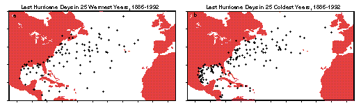

3. EMPIRICAL STUDIES
4. DATASET DEVELOPMENT AND MANAGEMENT
5. MODELING
5.1 Atmospheric General Circulation Models (AGCMs)
5.2 Mesoscale atmospheric models
5.3 Ocean General Circulation Models (OGCMs)
5.4 Coupled atmosphere-ocean GCMs
6. FIELD
STUDIES

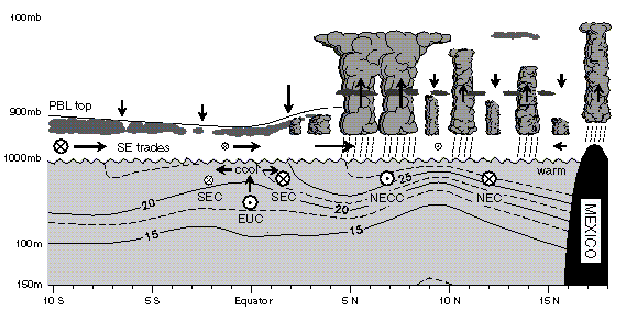
6.1 Work in progress in the tropical eastern Pacific

6.1.1 Atmospheric PBL structure above the cold tongue
6.1.2 Structure and intensity of ITCZ rainfall
6.1.3 Air-sea fluxes in the cold tongue-ITCZ-complex
6.1.4 Vertical current profiles in the equatorial cold tongue
6.2 Expanded monitoring in the tropical eastern Pacific
6.2.1 Atmospheric monitoring

6.2.2 Ocean monitoring
6.3 Process studies in the tropical eastern Pacific
6.3.1 Equatorial upwelling in the easterly regime
6.3.2 Atmospheric structure in the southerly regime
6.3.3 Atmosphere-ocean interaction in the stratus deck region
6.3.4 Equatorial SST variability in the southerly regime
7. RELATIONSHIP OF PACS TO OTHER
PROGRAMS
8. PROGRAM MANAGEMENT
REFERENCES
Candace Gudmundson gcg@atmos.washington.edu