| Latitude 35° 37´N |
Longitude 83° 6´W |
Elevation 799 meters |
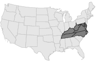
 COOP Mid-Atlantic |
 North Carolina |
Help Main |
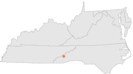
| 5 mi | S : | CATALOOCHEE RANCH, NC |
| 6 mi | W : | SPRUCE MOUNTAIN, NC |
| 7 mi | N : | MOUNT STERLING, NC |
| 10 mi | SSE : | EAGLENEST MOUNTAIN, NC |
| 10 mi | N : | WATERVILLE, NC |
| 10 mi | N : | WATERVILLE 2, NC |
| 12 mi | ESE : | CHAMBERS MOUNTAIN, NC |
| 12 mi | SE : | WAYNESVILLE 1 E, NC |
| 12 mi | NE : | MAPLE SPRING GAP 2, NC |
| 12 mi | NE : | MAPLE SPRINGS GAP, NC |