| Latitude 35° 9´N |
Longitude 82° 50´W |
Elevation 671 meters |
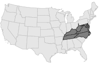
 COOP Mid-Atlantic |
 North Carolina |
Help Main |
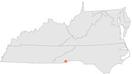
| 4 mi | WNW : | QUEBEC, NC |
| 8 mi | WSW : | LAKE TOXAWAY 2 SW, NC |
| 8 mi | N : | GLOUCESTER GAP, NC |
| 8 mi | N : | GLOUCESTER GAP, NC |
| 9 mi | ENE : | BREVARD, NC |
| 9 mi | WNW : | OWENS GAP, NC |
| 9 mi | N : | DAVIDSON RIVER FISH HATCHERY, NC |
| 9 mi | N : | PISGAH FOREST 8 W, NC |
| 11 mi | NE : | PISGAH FOREST 1 N, NC |
| 11 mi | E : | CEDAR MOUNTAIN, NC |