| Latitude 39° 6´N |
Longitude 79° 41´W |
Elevation 580 meters |
 COOP Mid-Atlantic |
 West Virginia |
Help Main |
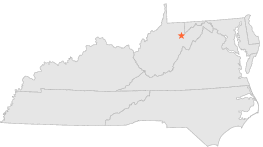
| 1 mi | E : | PARSONS 1 NE, WV |
| 10 mi | ENE : | THOMAS, WV |
| 12 mi | E : | DAVIS, WV |
| 13 mi | S : | ALPENA, WV |
| 13 mi | ESE : | CANNAAN VALLEY 2, WV |
| 14 mi | WSW : | BELINGTON, WV |
| 15 mi | ESE : | CANAAN VALLEY, WV |
| 16 mi | SW : | ELKINS, WV |
| 16 mi | N : | ROWLESBURG 1, WV |
| 17 mi | N : | ROWLESBURG 2, WV |