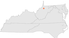
467883 - SALEM, West Virginia

Latitude
39° 17´N
Longitude
80° 34´W
Elevation
320 meters
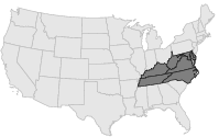
COOP Mid-Atlantic

West Virginia
Help

Main
10 nearest COOP Mid-Atlantic stations
1 miN :SALEM JACOBS RUN 2, WV
1 miNW :SALEM JACOBS RUN 1, WV
1 miSE :SALEM PATTERSON FORK JCT, WV
1 miSW :SALEM PATTERSON RIGHT FORK, WV
2 miS :SALEM PATTERSON LEFT FORK, WV
4 miE :LAKE FLOYD, WV
7 miSSE :ISAACS CREEK, WV
7 miESE :UPPER SYCAMORE CREEK, WV
7 miE :UPPER DAVISSON RUN, WV
7 miESE :COBURN CREEK, WV

Weather variables    Help
Click a weather variable name to jump down to those statistics.
Total
observations
%
NDJFM
observations
%
TMAX
199
1.1%
131
1.7%
TMIN
200
1.1%
131
1.7%
PRCP
2427
13.3%
973
12.9%
SNOW
2010
11.0%
679
9.0%


TMAX     top of page

Data not shown:
Less than 5% of days have TMAX observations during NDJFM over 1948-1997


TMIN     top of page

Data not shown:
Less than 5% of days have TMIN observations during NDJFM over 1948-1997


PRCP (total liquid water equivalent)     Help     top of page

PRCP
observations
mean
   
Distribution
during extreme days of
NDJFM
973  by year
0.12"
   
overall
NAM
PNA
CTI

PRCP and NAM    Help
scatterplot
days
by month
mean
mean
NAM index
extreme high
NAM days
extreme low
NAM days
ratio of extreme
high:low NAM days
Observed events
Days with PRCP>0.00"
299
0.40"
0.04
53
53
1.0
map
table
Extreme events
Days with PRCP>0.65"
59
0.99"
-0.05
8
14
1.8
map
table

PRCP and PNA    Help
scatterplot
days
by month
mean
mean
PNA index
extreme high
PNA days
extreme low
PNA days
ratio of extreme
high:low PNA days
Observed events
Days with PRCP>0.00"
299
0.40"
-0.19
36
62
1.7*
map
table
Extreme events
Days with PRCP>0.65"
59
0.99"
-0.57
4
17
4.2*
map
table

PRCP and CTI    Help
days
by month
mean
high CTI days
(moderate to strong
El Niño winters)
low CTI days
(moderate to strong
La Niña winters)
ratio of high:low CTI
(El Niño:La Niña days)
Observed events
Days with PRCP>0.00"
299
0.40"
17
95
5.6*
map
table
Extreme events
Days with PRCP>0.65"
59
0.99"
4
24
6.0*
map
table

PRCP under 2 index extremes     Help
Station table Maps - choose one extreme:
High NAMLow NAM High PNALow PNA High CTILow CTI


SNOW     Help     top of page

SNOW
observations
mean
   
Distribution
during extreme days of
NDJFM
679  by year
0.04"
   
overall
NAM
PNA
CTI

SNOW and NAM    Help
scatterplot
days
by month
mean
mean
NAM index
extreme high
NAM days
extreme low
NAM days
ratio of extreme
high:low NAM days
Observed events
Days with SNOW>0.0"
18
1.54"
0.26
4
2
2.0
map
table
Extreme events
Days with SNOW>3.0"
2
3.75"
0.63
1
0
Inf
map
table

SNOW and PNA    Help
scatterplot
days
by month
mean
mean
PNA index
extreme high
PNA days
extreme low
PNA days
ratio of extreme
high:low PNA days
Observed events
Days with SNOW>0.0"
18
1.54"
0.18
1
1
1.0
map
table
Extreme events
Days with SNOW>3.0"
2
3.75"
-0.64
0
1
Inf
map
table

SNOW and CTI    Help
days
by month
mean
high CTI days
(moderate to strong
El Niño winters)
low CTI days
(moderate to strong
La Niña winters)
ratio of high:low CTI
(El Niño:La Niña days)
Observed events
Days with SNOW>0.0"
18
1.54"
0
10
Inf
map
table
Extreme events
Days with SNOW>3.0"
2
3.75"
0
1
Inf
map
table

SNOW under 2 index extremes     Help
Station table Maps - choose one extreme:
High NAMLow NAM High PNALow PNA High CTILow CTI