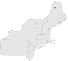
171430 - CHURCHILL DAM, Maine

Latitude
46° 30´N
Longitude
69° 17´W
Elevation
285 meters

COOP Northeast

Maine
Help

Main
10 nearest COOP Northeast stations
14 miNW :CLAYTON LAKE, ME
14 miNW :CLAYTON LAKE 2, ME
25 miSSE :TELOS DAM, ME
25 miESE :MILLINOCKET DAM, ME
37 miWNW :LAC FRONTIERE, ME
42 miNNE :ALLAGASH, ME
43 miS :RIPOGENUS DAM, ME
45 miE :SQUA PAN DAM, ME
49 miNE :EAGLE LAKE, ME
49 miNNE :ST FRANCIS, ME

Weather variables    Help
Click a weather variable name to jump down to those statistics.
Total
observations
%
NDJFM
observations
%
TMAX
1096
6.0%
330
4.4%
TMIN
1113
6.1%
343
4.5%
PRCP
1122
6.1%
343
4.5%
SNOW
998
5.5%
220
2.9%


TMAX     top of page

Data not shown:
Less than 5% of days have TMAX observations during NDJFM over 1948-1997


TMIN     top of page

Data not shown:
Less than 5% of days have TMIN observations during NDJFM over 1948-1997


PRCP (total liquid water equivalent)     top of page

Data not shown:
Less than 5% of days have PRCP observations during NDJFM over 1948-1997


SNOW     top of page

Data not shown:
Less than 5% of days have SNOW observations during NDJFM over 1948-1997