| Latitude 46° 41´N |
Longitude 68° 3´W |
Elevation 1480 meters |
 COOP Northeast |
 Maine |
Help Main |

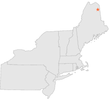
| 3 mi | SE : | PRESQUE ISLE, ME |
| 13 mi | N : | CARIBOU MUNICIPAL ARPT, ME |
| 16 mi | ENE : | FORT FAIRFIELD 5 NE, ME |
| 16 mi | SW : | SQUA PAN DAM, ME |
| 21 mi | SSE : | BRIDGEWATER, ME |
| 34 mi | N : | VAN BUREN 2, ME |
| 35 mi | SSE : | HOULTON 5 N, ME |
| 35 mi | NW : | EAGLE LAKE, ME |
| 39 mi | SSE : | HOULTON, ME |
| 40 mi | SSE : | HOULTON INTL AIRPORT, ME |