| Latitude 43° 0´N |
Longitude 111° 43´W |
Elevation 1891 meters |
 COOP Northwest |
 Idaho |
Help Main |
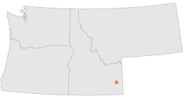
| 10 mi | ENE : | GRAY 6 NNW, ID |
| 11 mi | E : | GRAY, ID |
| 15 mi | N : | IDAHO FALLS 16 SE, ID |
| 21 mi | NE : | IRWIN 2 SE, ID |
| 21 mi | NE : | PALISADES, ID |
| 22 mi | NE : | SWAN VALLEY 2 E, ID |
| 24 mi | N : | RIRIE 12 ESE, ID |
| 26 mi | N : | RIRIE, ID |
| 31 mi | SSE : | WAYAN 1 S, ID |
| 32 mi | S : | HENRY, ID |