| Latitude 48° 17´N |
Longitude 111° 20´W |
Elevation 1196 meters |
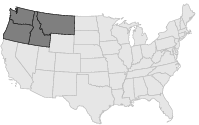
 COOP Northwest |
 Montana |
Help Main |
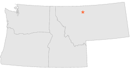
| 2 mi | SW : | GALATA 16 SSW, MT |
| 7 mi | ENE : | TIBER DAM, MT |
| 8 mi | SSE : | BRADY 27 ENE THE KNEES, MT |
| 12 mi | SE : | RUSSELL, MT |
| 13 mi | WSW : | CONRAD 9 ESE MSR, MT |
| 16 mi | WNW : | SHELBY 7 S, MT |
| 17 mi | WNW : | SHELBY, MT |
| 18 mi | WSW : | CONRAD, MT |
| 18 mi | NW : | SHELBY AIRPORT, MT |
| 19 mi | NNW : | DUNKIRK 15 NNE, MT |