| Latitude 45° 14´N |
Longitude 108° 16´W |
Elevation 1159 meters |
 COOP Northwest |
 Montana |
Help Main |
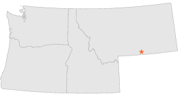
| 6 mi | S : | PRYOR 27 SE HILLSBORO, MT |
| 11 mi | NW : | PRYOR, MT |
| 15 mi | WNW : | EDGAR 9 SE, MT |
| 17 mi | NW : | EDGAR 6 E, MT |
| 19 mi | W : | BRIDGER 1 S, MT |
| 23 mi | NNW : | BILLINGS WATER PLANT, MT |
| 23 mi | WNW : | JOLIET, MT |
| 24 mi | NW : | LAUREL 3 WSW, MT |
| 25 mi | NNW : | BILLINGS LOGAN INT'L ARPT, MT |
| 29 mi | N : | HUNTLEY EXPERIMENT STN, MT |