| Latitude 45° 43´N |
Longitude 120° 42´W |
Elevation 58 meters |
 COOP Northwest |
 Oregon |
Help Main |
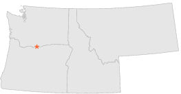
| 0 mi | N : | JOHN DAY DAM, WA |
| 5 mi | NW : | GOLDENDALE, WA |
| 5 mi | NW : | GOLDENDALE, WA |
| 6 mi | S : | WASCO, OR |
| 7 mi | W : | CENTERVILLE 2 SW, WA |
| 10 mi | S : | MORO, OR |
| 10 mi | N : | SATUS PASS 2 SSW, WA |
| 15 mi | SE : | MIKKALO 6 W, OR |
| 15 mi | E : | ARLINGTON, OR |
| 17 mi | SE : | MIKKALO NISH RANCH, OR |