| Latitude 33° 38´N |
Longitude 86° 11´W |
Elevation 156 meters |
 COOP Southeast |
 Alabama |
Help Main |
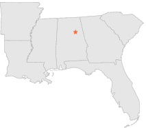
| 5 mi | WSW : | PELL CITY 1 NNE, AL |
| 7 mi | WSW : | PELL CITY, AL |
| 7 mi | S : | JACKSON SHOALS, AL |
| 8 mi | WSW : | PELL CITY 2 W, AL |
| 15 mi | S : | TALLADEGA, AL |
| 16 mi | SSW : | LOGAN MARTIN DAM, AL |
| 17 mi | NNW : | ASHVILLE 4 W, AL |
| 19 mi | E : | ANNISTON CALHOUN CO AP, AL |
| 19 mi | E : | ANNISTON MUNICIPAL AP, AL |
| 20 mi | E : | ANNISTON, AL |