| Latitude 35° 49´N |
Longitude 91° 47´W |
Elevation 153 meters |
 COOP Southeast |
 Arkansas |
Help Main |
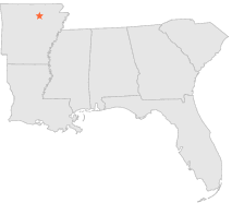
| 1 mi | NE : | BATESVILLE LIVESTOCK, AR |
| 4 mi | WNW : | LOCK AND DAM 3, AR |
| 8 mi | ESE : | BATESVILLE AIRWAY, AR |
| 10 mi | ESE : | BATESVILLE L&D 1, AR |
| 19 mi | WNW : | MOUNTAIN VIEW, AR |
| 21 mi | NNE : | EVENING SHADE 1 NNE, AR |
| 22 mi | NNW : | MELBOURNE 5 WNW, AR |
| 24 mi | SW : | HEBER SPRINGS 3 NE, AR |
| 24 mi | SSW : | GREERS FERRY DAM, AR |
| 24 mi | E : | WALNUT GROVE 2 NNE, AR |