| Latitude 34° 12´N |
Longitude 94° 15´W |
Elevation 159 meters |
 COOP Southeast |
 Arkansas |
Help Main |
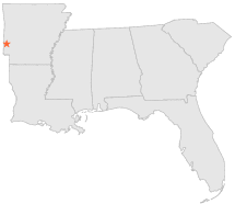
| 6 mi | NW : | GRANNIS, AR |
| 10 mi | ESE : | DIERKS DAM, AR |
| 13 mi | SSW : | DEQUEEN, AR |
| 13 mi | NW : | BOGG SPRINGS, AR |
| 14 mi | ESE : | DIERKS, AR |
| 17 mi | ENE : | ATHENS, AR |
| 19 mi | NNW : | COVE, AR |
| 20 mi | SSW : | HORATIO, AR |
| 20 mi | E : | NEWHOPE 6 S, AR |
| 23 mi | ESE : | NATHAN 4 WNW, AR |