| Latitude 40° 55´N |
Longitude 121° 40´W |
Elevation 960 meters |
 COOP Southwest |
 California |
Help Main |
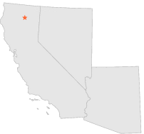
| 1 mi | S : | BURNEY, CA |
| 4 mi | E : | HAT CREEK, CA |
| 4 mi | SW : | HATCHET MOUNTAIN MNTNC STN, CA |
| 6 mi | WSW : | BUCKHORN, CA |
| 7 mi | SE : | HAT CREEK EXPERIMENT STN, CA |
| 9 mi | WSW : | MONTGOMERY CREEK, CA |
| 9 mi | WSW : | ROUND MOUNTAIN, CA |
| 10 mi | WSW : | ROUND MOUNTAIN PG & E, CA |
| 10 mi | WNW : | PIT RIVER P H 5, CA |
| 12 mi | SSW : | KILARC PH, CA |