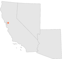
041961 - CONCORD 2 SE, California

Latitude
37° 57´N
Longitude
122° 0´W
Elevation
79 meters

COOP Southwest

California
Help

Main
10 nearest COOP Southwest stations
1 miNNW :CONCORD AIRPORT, CA
2 miSSW :WALNUT CREEK 2 ENE, CA
3 miWNW :CONCORD WASTEWATER PLANT, CA
3 miW :WALMAR SCHOOL, CA
3 miSSW :WALNUT CREEK 2 ESE, CA
3 miWNW :MARTINEZ 3 SSE, CA
3 miS :LIVORNA HEIGHTS, CA
4 miWSW :LA FAYETTE 3 NNE, CA
4 miSSW :ALAMO 1 N, CA
4 miSW :BURTON RANCH, CA

Weather variables    Help
Click a weather variable name to jump down to those statistics.
Total
observations
%
NDJFM
observations
%
TMAX
0
0.0%
0
0.0%
TMIN
0
0.0%
0
0.0%
PRCP
363
2.0%
146
1.9%
SNOW
365
2.0%
145
1.9%


TMAX     top of page

Data not shown:
Less than 5% of days have TMAX observations during NDJFM over 1948-1997

No TMAX extreme events during NDJFM over 1948-1997


TMIN     top of page

Data not shown:
Less than 5% of days have TMIN observations during NDJFM over 1948-1997

No TMIN extreme events during NDJFM over 1948-1997


PRCP (total liquid water equivalent)     top of page

Data not shown:
Less than 5% of days have PRCP observations during NDJFM over 1948-1997


SNOW     top of page

Data not shown:
Less than 5% of days have SNOW observations during NDJFM over 1948-1997

No days with measureable SNOW during NDJFM over 1948-1997