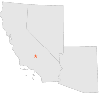
049512 - WELDON 1 WSW, California

Latitude
35° 40´N
Longitude
118° 18´W
Elevation
817 meters

COOP Southwest

California
Help

Main
10 nearest COOP Southwest stations
5 miWNW :WOFFORD HEIGHTS KERN, CA
5 miWNW :WOFFORD HEIGHTS KERNVILLE, CA
7 miNW :KERN RIVER PH 3, CA
9 miWNW :GREENHORN MTN PARK, CA
13 miWNW :POSEY 3 E, CA
13 miWNW :POSEY 4 ENE, CA
13 miSW :MOUNT BECKENRIDGE, CA
13 miWNW :GLENNVILLE FULTON RNGR STN, CA
13 miNNW :KERN RIVER INTAKE 3, CA
14 miWNW :GLENNVILLE, CA

Weather variables    Help
Click a weather variable name to jump down to those statistics.
Total
observations
%
NDJFM
observations
%
TMAX
0
0.0%
0
0.0%
TMIN
0
0.0%
0
0.0%
PRCP
843
4.6%
367
4.9%
SNOW
123
0.7%
0
0.0%


TMAX     top of page

Data not shown:
Less than 5% of days have TMAX observations during NDJFM over 1948-1997

No TMAX extreme events during NDJFM over 1948-1997


TMIN     top of page

Data not shown:
Less than 5% of days have TMIN observations during NDJFM over 1948-1997

No TMIN extreme events during NDJFM over 1948-1997


PRCP (total liquid water equivalent)     top of page

Data not shown:
Less than 5% of days have PRCP observations during NDJFM over 1948-1997


SNOW     top of page

Data not shown:
Less than 5% of days have SNOW observations during NDJFM over 1948-1997

No days with measureable SNOW during NDJFM over 1948-1997