| Latitude 40° 54´N |
Longitude 119° 18´W |
Elevation 1260 meters |
 COOP Southwest |
 Nevada |
Help Main |
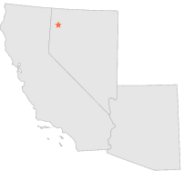
| 10 mi | S : | GERLACH, NV |
| 13 mi | S : | GERLACH, NV |
| 18 mi | SW : | SMOKE CREEK ESPIL, NV |
| 29 mi | SSW : | SAND PASS, NV |
| 41 mi | E : | SULPHUR, NV |
| 46 mi | N : | SOLDIERS MEADOW, NV |
| 48 mi | E : | JUNGO MEYER RANCH, NV |
| 51 mi | W : | TERMO BRIN MARR, CA |
| 52 mi | W : | SECRET VALLEY M S, CA |
| 52 mi | WSW : | WENDEL 10 SE, CA |