| Latitude 42° 29´N |
Longitude 78° 56´W |
Elevation 265 meters |
 COOP Northeast |
 New York |
Help Main |

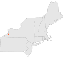
| 0 mi | N : | HELMUTH FIRE CONTROL, NY |
| 5 mi | WSW : | PERRYSBURG 1 SW, NY |
| 12 mi | N : | EDEN, NY |
| 12 mi | WNW : | SILVER CREEK 2 NE, NY |
| 13 mi | S : | NEW ALBION, NY |
| 14 mi | S : | NEW ALBION 1 W, NY |
| 15 mi | NNW : | DERBY 2 NW, NY |
| 15 mi | W : | FREDONIA, NY |
| 17 mi | SSE : | LITTLE VALLEY, NY |
| 18 mi | W : | CHAUTAUQUA COUNTY AIRPORT, NY |