| Latitude 44° 5´N |
Longitude 115° 34´W |
Elevation 1180 meters |
 COOP Northwest |
 Idaho |
Help Main |
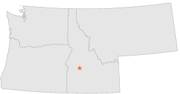
| 0 mi | N : | LOWMAN 3E #2, ID |
| 1 mi | W : | LOWMAN, ID |
| 10 mi | NNW : | DEADWOOD DAM, ID |
| 12 mi | W : | GARDEN VALLEY, ID |
| 12 mi | WNW : | CROUCH 2 NNW, ID |
| 16 mi | N : | DEADWOOD DAM 15 N, ID |
| 18 mi | NW : | ALPHA 1 NE, ID |
| 29 mi | N : | YELLOW PINE 7 S, ID |
| 31 mi | NNE : | MIDDLE FORK LODGE, ID |
| 34 mi | SSW : | CENTERVILLE ARBAUGH RANCH, ID |