| Latitude 47° 57´N |
Longitude 123° 16´W |
Elevation 1607 meters |
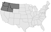
 COOP Northwest |
 Washington |
Help Main |
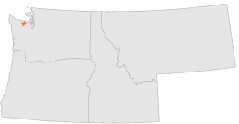
| 15 mi | WSW : | BLUE GLACIER, WA |
| 17 mi | W : | SOL DUC HOT SPRINGS, WA |
| 22 mi | S : | CUSHMAN DAM, WA |
| 24 mi | S : | CUSHMAN POWERHOUSE 2, WA |
| 26 mi | SW : | QUINAULT RANGER STN, WA |
| 26 mi | SW : | AMANDA PARK, WA |
| 27 mi | ESE : | QUILCENE 5 SW DAM, WA |
| 29 mi | E : | QUILCENE 2 SW, WA |
| 30 mi | SSW : | MATLOCK 3 W, WA |
| 31 mi | SSW : | ABERDEEN 20 NNE, WA |