| Latitude 47° 58´N |
Longitude 123° 52´W |
Elevation 503 meters |
 COOP Northwest |
 Washington |
Help Main |
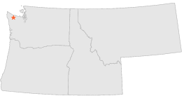
| 7 mi | SSE : | BLUE GLACIER, WA |
| 17 mi | E : | PORT ANGELES 14 SE, WA |
| 21 mi | S : | AMANDA PARK, WA |
| 21 mi | S : | QUINAULT RANGER STN, WA |
| 25 mi | WSW : | SPRUCE, WA |
| 28 mi | WSW : | KELLYS RANCH, WA |
| 29 mi | SE : | CUSHMAN DAM, WA |
| 29 mi | S : | ABERDEEN 20 NNE, WA |
| 31 mi | S : | HUMPTULIPS SALMON HATCHERY, WA |
| 31 mi | NNE : | ELWHA R S, WA |