| Latitude 47° 15´N |
Longitude 119° 50´W |
Elevation 403 meters |
 COOP Northwest |
 Washington |
Help Main |
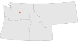
| 1 mi | SSW : | QUINCY 1 S, WA |
| 8 mi | ENE : | EPHRATA, WA |
| 9 mi | ENE : | EPHRATA AP FCWOS, WA |
| 18 mi | ESE : | MOSES LAKE, WA |
| 19 mi | ESE : | MOSES LAKE 3 E, WA |
| 19 mi | N : | WITHROW, WA |
| 21 mi | ENE : | WILSON CREEK, WA |
| 23 mi | ESE : | RUFF 3 SW, WA |
| 23 mi | N : | MANSFIELD 7 W, WA |
| 24 mi | W : | TRINIDAD 2 SSE, WA |