| Latitude 46° 56´N |
Longitude 119° 39´W |
Elevation 317 meters |
 COOP Northwest |
 Washington |
Help Main |
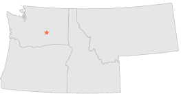
| 2 mi | E : | ROYAL CITY 3 NE, WA |
| 4 mi | S : | SMYRNA, WA |
| 14 mi | SSW : | PRIEST RAPIDS DAM, WA |
| 18 mi | ESE : | OTHELLO 6 ESE, WA |
| 22 mi | SE : | MESA 4 W, WA |
| 23 mi | SE : | ELTOPIA 6 W, WA |
| 26 mi | SSE : | ELTOPIA 8 WSW, WA |
| 27 mi | S : | BENTON CITY 2 NW, WA |
| 28 mi | SSE : | RICHLAND, WA |
| 31 mi | S : | PROSSER, WA |