| Latitude 30° 34´N |
Longitude 90° 55´W |
Elevation 18 meters |
 COOP Southeast |
 Louisiana |
Help Main |
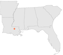
| 4 mi | W : | GREENWELL SPRINGS, LA |
| 6 mi | N : | STONYPOINT, LA |
| 7 mi | W : | BATON ROUGE CENTRAL, LA |
| 8 mi | SSW : | DENHAM SPRINGS, LA |
| 10 mi | E : | NORTH LIVINGSTON, LA |
| 11 mi | ESE : | LIVINGSTON, LA |
| 11 mi | SW : | BATON ROUGE SHERWOOD, LA |
| 13 mi | NNW : | OAKNOLIA 2 N, LA |
| 14 mi | NE : | PINE GROVE FIRE TOWER, LA |
| 14 mi | W : | BATON ROUGE RYAN ARPT, LA |