| Latitude 30° 33´N |
Longitude 91° 2´W |
Elevation 18 meters |
 COOP Southeast |
 Louisiana |
Help Main |
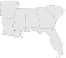
| 3 mi | ENE : | GREENWELL SPRINGS, LA |
| 7 mi | S : | BATON ROUGE SHERWOOD, LA |
| 7 mi | SE : | DENHAM SPRINGS, LA |
| 7 mi | E : | WATSON 3 ESE, LA |
| 7 mi | W : | BATON ROUGE RYAN ARPT, LA |
| 8 mi | W : | BAKER, LA |
| 9 mi | NE : | STONYPOINT, LA |
| 11 mi | NNW : | ZACHARY, LA |
| 11 mi | SSW : | BATON ROUGE CONCORD, LA |
| 11 mi | SW : | BATON ROUGE LA UNIV, LA |