| Latitude 38° 52´N |
Longitude 117° 35´W |
Elevation 2114 meters |
 COOP Southwest |
 Nevada |
Help Main |
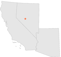
| 11 mi | W : | GABBS, NV |
| 14 mi | ESE : | SMOKEY VALLEY, NV |
| 21 mi | SE : | MANHATTAN POWER HOUSE, NV |
| 22 mi | SE : | WILLOW SPRINGS, NV |
| 35 mi | SSE : | TONOPAH, NV |
| 35 mi | SSW : | COALDALE, NV |
| 36 mi | N : | REESE RIVER O'TOOLE, NV |
| 37 mi | SSE : | TONOPAH AIRPORT, NV |
| 43 mi | WSW : | MINA, NV |
| 47 mi | NNW : | EASTGATE, NV |