| Latitude 47° 15´N |
Longitude 68° 36´W |
Elevation 153 meters |
 COOP Northeast |
 Maine |
Help Main |

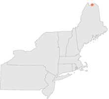
| 1 mi | SW : | FORT KENT, ME |
| 15 mi | S : | EAGLE LAKE, ME |
| 15 mi | WSW : | ST FRANCIS, ME |
| 21 mi | E : | GRAND ISLE, ME |
| 23 mi | WSW : | ALLAGASH, ME |
| 32 mi | E : | VAN BUREN 2, ME |
| 38 mi | SE : | CARIBOU MUNICIPAL ARPT, ME |
| 47 mi | SSE : | PRESQUE ISLE MUNICIP, ME |
| 50 mi | SSE : | SQUA PAN DAM, ME |
| 50 mi | SE : | FORT FAIRFIELD 5 NE, ME |