| Latitude 43° 48´N |
Longitude 115° 7´W |
Elevation 1705 meters |
 COOP Northwest |
 Idaho |
Help Main |
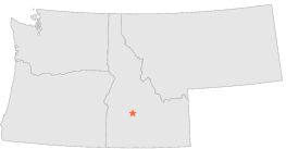
| 0 mi | N : | ATLANTA 2, ID |
| 1 mi | W : | ATLANTA, ID |
| 9 mi | SSW : | FEATHERVILLE, ID |
| 15 mi | SSW : | PINE 2 S, ID |
| 17 mi | WNW : | MOBES CREEK SUMMIT, ID |
| 19 mi | SW : | PRAIRIE, ID |
| 21 mi | SSW : | ANDERSON DAM, ID |
| 21 mi | S : | HILL CITY 1 W, ID |
| 22 mi | W : | IDAHO CITY, ID |
| 23 mi | WNW : | CENTERVILLE ARBAUGH RANCH, ID |