| Latitude 44° 55´N |
Longitude 123° 35´W |
Elevation 1094 meters |
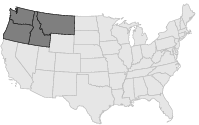
 COOP Northwest |
 Oregon |
Help Main |
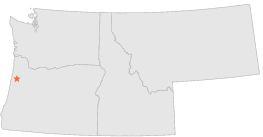
| 4 mi | SW : | VALSETZ, OR |
| 5 mi | SE : | FALLS CITY 1 SW, OR |
| 5 mi | ESE : | FALLS CITY NO 2, OR |
| 9 mi | E : | DALLAS 2 NE, OR |
| 10 mi | SSE : | HOSKINS, OR |
| 12 mi | S : | SUMMIT, OR |
| 17 mi | SE : | CORVALLIS STATE UNIV, OR |
| 17 mi | SSE : | CORVALLIS WATER BUREAU, OR |
| 17 mi | E : | SALEM MCNARY FIELD, OR |
| 18 mi | SSE : | PHILOMATH 2 SE, OR |