| Latitude 42° 58´N |
Longitude 120° 47´W |
Elevation 1278 meters |
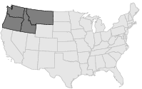
 COOP Northwest |
 Oregon |
Help Main |
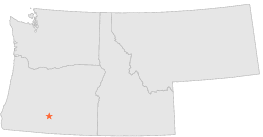
| 13 mi | SE : | PAISLEY, OR |
| 24 mi | E : | ALKALI LAKE, OR |
| 25 mi | SE : | VALLEY FALLS, OR |
| 26 mi | S : | ROUND GROVE, OR |
| 27 mi | SE : | VALLEY FALLS 3 SSE, OR |
| 34 mi | SSE : | LAKEVIEW 2 NNW, OR |
| 37 mi | SW : | BLY RANGER STN, OR |
| 37 mi | SW : | BLY 3 NW, OR |
| 39 mi | N : | CHRISTMAS VALLEY, OR |
| 39 mi | N : | CHRISTMAS VALLEY 11 W, OR |