| Latitude 32° 22´N |
Longitude 87° 39´W |
Elevation 70 meters |
 COOP Southeast |
 Alabama |
Help Main |
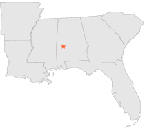
| 10 mi | NE : | UNIONTOWN, AL |
| 16 mi | NW : | DEMOPOLIS LOCK 4, AL |
| 16 mi | SE : | ALBERTA, AL |
| 16 mi | S : | MAGNOLIA, AL |
| 17 mi | NW : | DEMOPOLIS LOCK AND DAM, AL |
| 22 mi | WSW : | WHITFIELD LOCK 3, AL |
| 22 mi | WSW : | WHITFIELD LOCK 3, AL |
| 23 mi | N : | GREENSBORO, AL |
| 23 mi | SE : | MILLERS FERRY L & D, AL |
| 24 mi | WSW : | PENNINGTON 2 NE, AL |